Transfagarasan Highway Guide
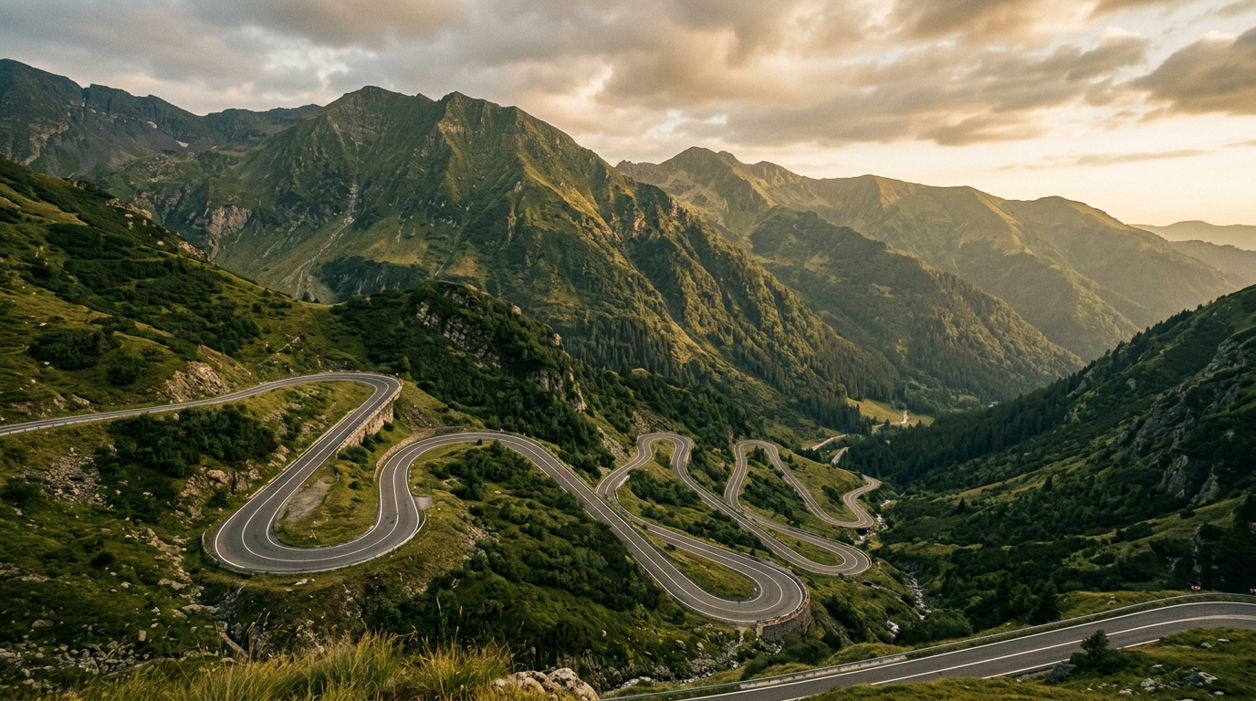
Jeremy Clarkson called it the best road in the world. We will not go that far – the man has a flair for the superlative and a show to sell – but we will say this: the Transfagarasan is the single most dramatic paved road we have driven in the Balkans, and we have driven most of them. Ninety kilometers of engineered audacity cutting through the Fagaras Mountains, climbing to 2,042 meters, threading through tunnels blasted out of raw granite, with views that expand in every direction until you run out of adjectives.
The DN7C connects Curtea de Arges in the south with Sibiu in the north, crossing the highest section of the Southern Carpathians. It was built between 1970 and 1974 on the orders of Nicolae Ceausescu as a military road – a strategic route through the mountains in case of Soviet invasion. The irony is that a dictator’s paranoia produced one of Europe’s great driving experiences. The road cost the lives of 40 workers during construction and consumes roughly 6,000 tonnes of de-icing salt before it opens each summer. Romania maintains it because the world keeps showing up to drive it.
Essential Information
| Detail | Information |
|---|---|
| Road number | DN7C |
| Total length | ~90 km (Curtea de Arges to Sibiu) |
| Summit altitude | 2,042 m (Balea Lake) |
| Open season | Typically late June to late October |
| Drive time (no stops) | 3-4 hours |
| Toll/fee | None |
| Road surface | Good asphalt throughout |
| Fuel | None on the mountain – fill up before |
The road is closed for most of the year. Snow blocks the summit section from roughly November to June. The exact opening date varies by year and depends on snowfall – it can be as early as June 15 or as late as July 1. Check the Romanian road authority (CNAIR) website or search “Transfagarasan open” before planning your drive. The road sometimes closes temporarily in summer due to weather events.
Tip: The opening and closing dates are not fixed. We have arrived on June 20 and found the summit still closed, and we have driven it in late October with snow on the ground but the road still officially open. Check the week before you go, not the month before.
North Approach vs South Approach
You can drive the Transfagarasan in either direction, and the experience differs significantly.
| South Approach (from Curtea de Arges) | North Approach (from Sibiu) | |
|---|---|---|
| Starting point | Curtea de Arges (altitude 430m) | Cartisoara / Sibiu (altitude 450m) |
| Character | Gradual climb, then dramatic hairpins | Steady ascent through forest, then open plateau |
| Best feature | The south face hairpins (legendary switchbacks) | Balea Waterfall approach, wide valley views |
| Vidraru Dam | Included at the start | Requires a detour after |
| Morning light | Sun behind you climbing south face | Sun in your face descending south face |
| Crowds | Meet tourist traffic head-on at the summit | Arrive at summit from less crowded side |
Our recommendation: Drive south to north if you want the full dramatic buildup – Vidraru Dam first, then the legendary hairpin section climbing the south face, arriving at Balea Lake at the summit. Drive north to south if you are coming from Sibiu and want to save time, or if you prefer the south face hairpins as a descent (easier on the brakes, terrifying for passengers).
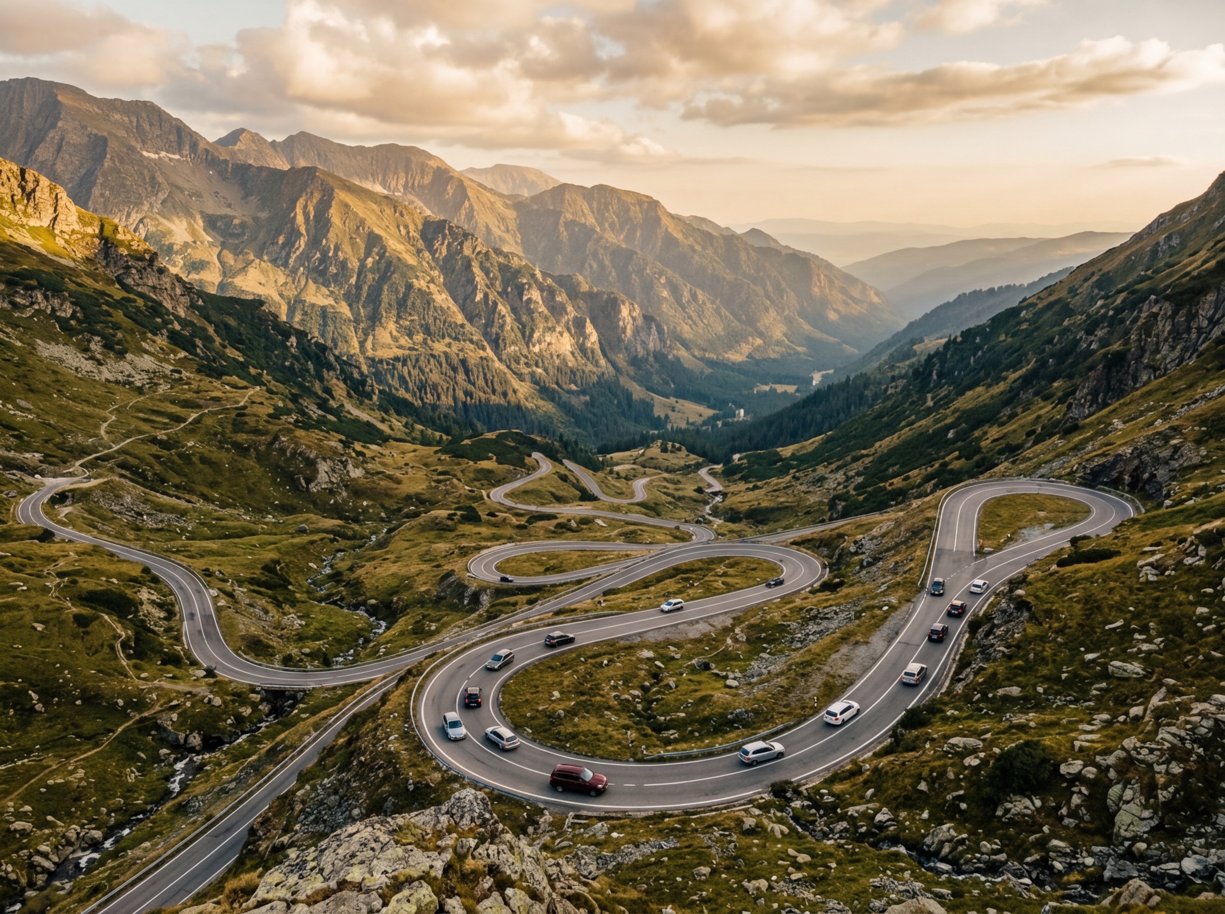
The south face is where the road earns its reputation. A series of switchbacks climb roughly 800 vertical meters in about 15 km, each hairpin revealing a wider view than the last. In a car, the turns are tight but manageable. On a motorcycle, this section is the reason the Transfagarasan appears on every “must-ride” list in Europe.
Starting from the South: Curtea de Arges
Curtea de Arges is a small city at the southern foot of the Fagaras Mountains and the traditional starting point for the south approach. The city itself has two notable stops:
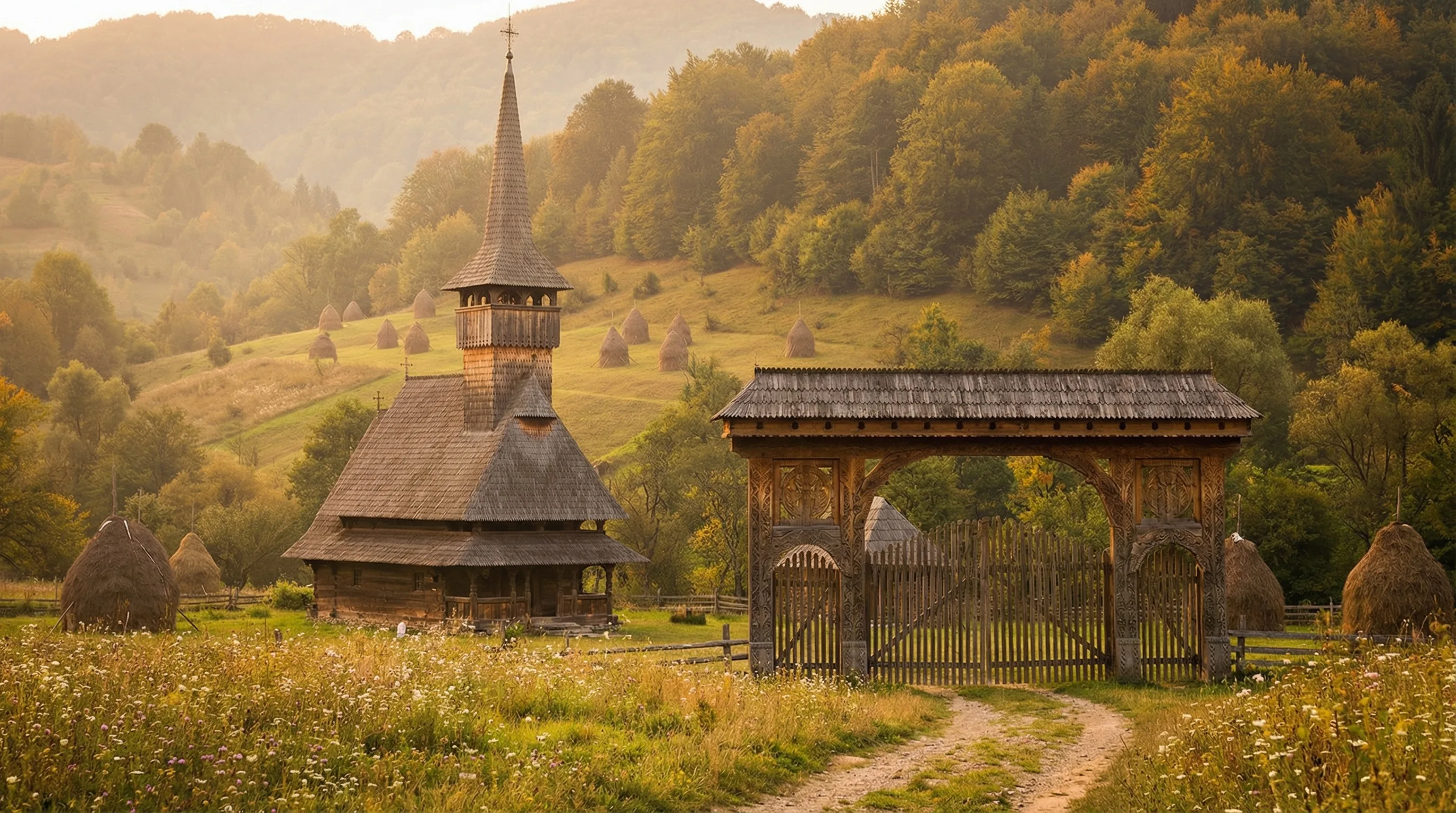
- Curtea de Arges Monastery: A 16th-century masterpiece of Wallachian architecture with elaborately twisted columns and geometric stonework. Legend says the master builder was walled into the structure by the prince to ensure he would never build anything more beautiful. Romanians take their architectural legends seriously. Free entry, 30 minutes.
- Ruins of the Royal Court: The 14th-century ruins that give the city its name (“Court of Arges”). Minor but interesting if you have time.
Fill your tank here. The next fuel station is on the other side of the mountains in Cartisoara, roughly 90 km and 3-4 hours away.
Vidraru Dam
Twenty-five kilometers north of Curtea de Arges, the road passes over the Vidraru Dam, a 166-meter-high arch dam holding back a reservoir of vivid blue-green water. The dam is the sixth-highest in Europe, and driving across its narrow top – with the reservoir on one side and a 166-meter drop on the other – is the kind of casual thrill that the Transfagarasan deals in before you even reach the mountain section.
There is a parking area at the dam where you can stop, walk to the edge, and peer over. A large statue of Prometheus stands at one end (placed there in 1966, because Romania in the 1960s was deeply committed to dramatic public art).
The lake behind the dam is worth a pause for photographs. The water color shifts between turquoise and deep blue depending on the season and light, and the forested shores are uninhabited.
The South Face: Hairpins
After the dam, the road runs through the Arges valley for about 20 km before the serious climbing begins. The transition is clear – the road starts to curve more sharply, the gradient increases, and you enter a series of tunnels before the famous hairpin section opens up.
The south face hairpins are roughly 15 km of continuous switchbacks. The road is well-maintained and has guardrails, but it is narrow – two lanes, with oncoming traffic coming down as you climb up. In summer, the traffic includes tour buses, which take the hairpins wide and slowly.
Driving the Hairpins
- Gear: Use a low gear climbing. Engine braking descending. Your brake pads will thank you.
- Speed: 20-40 km/h through the hairpins. There is no benefit to rushing.
- Stopping: Several pull-offs at the hairpins offer views back down the valley. Stop at them – the views are the entire point.
- Traffic: In July-August, expect slow-moving traffic in both directions. Tour buses are the bottleneck. Patience is required and rewarded.
- Motorcycles: The Transfagarasan is a pilgrimage road for European motorcyclists. They are everywhere in summer, and most ride sensibly. Watch for the ones who don’t.
Balea Lake (The Summit)
At 2,042 meters, Balea Lake is the highest point of the Transfagarasan and the natural midpoint stop. The lake is a glacial cirque – a cold, clear pool surrounded by bare rock and scree, with snow lingering on the slopes well into July.
The summit area has:
- A large parking lot (free, fills up by midday in summer)
- A couple of restaurant/cafe buildings (basic food, hot drinks, inflated prices – a bowl of soup costs RON 30-40 / EUR 6-8)
- A cable car down to Balea Waterfall (RON 40 / ~EUR 8 one way, seasonal)
- Souvenir stalls selling sheepskin hats and carved wooden items
- Toilets (paid, RON 2)
The temperature at the summit can be 15-20 degrees colder than the valley floor. Bring a jacket even if it is July. Weather changes rapidly at this altitude – we have experienced sunshine, fog, rain, and near-freezing wind in a single hour at Balea Lake.
Tip: Arrive at Balea Lake before 10:00 AM or after 4:00 PM to avoid the worst crowds. Between those hours in July-August, the parking lot is full and the restaurants are packed. The early morning option is better – the light is superior and the lake is still.
Balea Waterfall
About 6 km north (downhill) from Balea Lake, Balea Waterfall (Cascada Balea) drops 60 meters down a cliff face beside the road. There is a small parking area and a short walk to the viewpoint. In spring, when snowmelt feeds the waterfall, the volume is impressive. By late summer, it diminishes.
The cable car from Balea Lake terminates near the waterfall, making a hike-and-ride combination possible: drive to the summit, take the cable car down to the waterfall, explore, then ride back up.
The North Side Descent
The north side of the Transfagarasan is less dramatic than the south face – the descent is more gradual, through alpine meadows and then forest, without the concentrated hairpin spectacle of the south. It is still a beautiful road, but the intensity is lower. Most people feel a sense of “the main event is over” on this section, which is fine. Enjoy the gentler scenery.
The road descends into the village of Cartisoara, where you will find the first fuel station north of the mountains (fill up if you are running low). From Cartisoara, Sibiu is about 30 km north – a city that absolutely warrants a stop.
Combining with Sibiu
Sibiu is one of Romania’s finest cities – a Saxon-German town with a medieval center, baroque squares, and the famous “eye houses” (houses with window-like openings in the roofs that look like they are watching you). If you drive the Transfagarasan north to south, start in Sibiu. If south to north, end in Sibiu.
Budget at least half a day for Sibiu. The Piata Mare (Grand Square), the Brukenthal Museum, and a walk along the medieval city walls are the essentials. The restaurants in the old town are excellent and significantly cheaper than equivalent quality in Western Europe.
Practical Information
When to Go
The road is typically open from late June to late October. Within that window:
| Month | Conditions |
|---|---|
| Late June | Snow may still be clearing; road may open partially. Check dates. |
| July | Open, warm in valleys, cool at summit. Peak tourist traffic. |
| August | Similar to July. Hottest month in the valleys (35+ degrees below). |
| September | Excellent month. Fewer tourists, autumn color beginning, stable weather. |
| October | Growing risk of early snow. Days are shorter. Some summit facilities close. |
What to Drive
Any car can handle the Transfagarasan. The road is fully paved and well-maintained. The challenges are gradient and curves, not road surface. Automatic transmission makes the hairpins more relaxing. If you are in a manual, practice smooth heel-toe downshifts or prepare for a workout.
Campervans and caravans can drive the Transfagarasan but will struggle with the tight hairpins on the south face. Large motorhomes (over 7 meters) should seriously reconsider.
Safety
The Transfagarasan is not a dangerous road if you drive at appropriate speeds and stay in your lane. The main risks are:
- Fatigue: 3-4 hours of mountain driving with constant concentration. Take breaks.
- Weather: Fog can roll in at the summit without warning, reducing visibility to meters. Slow down and use fog lights.
- Other drivers: Some treat the road as a racetrack. Let them pass.
- Altitude: At 2,042m, some people experience mild altitude effects (lightheadedness). Drink water.
Fuel and Supplies
No fuel stations between Curtea de Arges (south) and Cartisoara (north) – roughly 90 km. Fill up before starting. Mountain restaurants at Balea Lake exist but are basic and expensive. Bring water and snacks.
Combining with Other Routes
- Vidraru Dam + Transfagarasan: Natural combination, included in the south approach.
- Transylvania castles: From Sibiu (north end), continue east to the Transylvania castle circuit – Bran, Peles, and Corvin.
- From Bulgaria: Cross into Romania at Ruse or Vidin, drive north to Curtea de Arges, and tackle the Transfagarasan as a standalone day.
- Grand loop: Combine the Transfagarasan with the Transalpina highway (DN67C, parallel mountain road 50 km west) for a two-day Carpathian mountain driving tour.
For general Romania driving information – vignette requirements, speed cameras, insurance – see our Romania hub page and the driving guide.