Djerdap Gorge: The Danube Drive
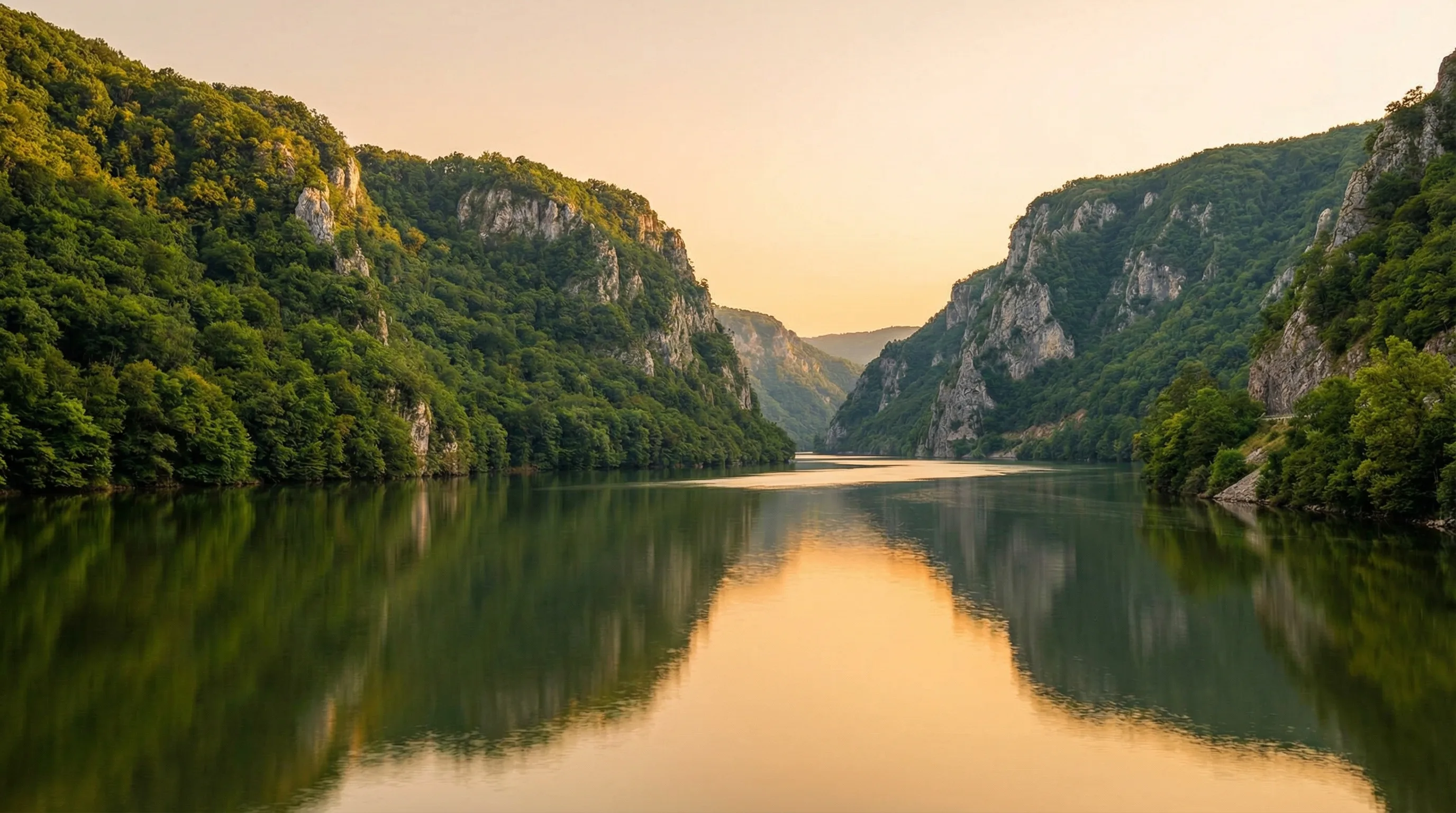
There is a stretch of the Danube between Serbia and Romania where Europe’s largest river forces its way through the Carpathian Mountains, creating a gorge so deep and narrow that the Romans carved inscriptions into the cliff walls just to prove they had been there. The Djerdap Gorge – also called the Iron Gates – runs for about 100 km from the medieval fortress at Golubac to the hydroelectric dam at Kladovo, and the road that follows it is the finest riverside drive in the Balkans.
We came here expecting a scenic road. What we found was a drive through 9,000 years of continuous human history, from a Mesolithic fishing settlement that challenges assumptions about prehistoric life to a Roman military highway that makes modern road engineering look timid. The Danube here is wide, slow, and green, and the Romanian shore rises opposite in mirrored cliffs. For most of the drive, there are no other cars.
Route Overview
The drive follows the Danube eastward from Golubac to Kladovo on a road that is technically part of the E25, though it feels nothing like a European main route.
| Segment | Distance | Drive Time | Highlight |
|---|---|---|---|
| Belgrade to Golubac | 140 km | 2 hours | Highway then two-lane road |
| Golubac to Donji Milanovac | 40 km | 45 min | Golubac Fortress, gorge entrance |
| Donji Milanovac to Lepenski Vir | 15 km | 20 min | Museum, 9000 BC settlement |
| Lepenski Vir to Tabula Traiana | 10 km | 15 min | Roman inscription |
| Tabula Traiana to Kladovo | 35 km | 40 min | Iron Gates dam |
| Total (Golubac to Kladovo) | ~100 km | ~2 hours |
Drive times assume no stops, which is unrealistic. Plan a full day. Better yet, overnight in Donji Milanovac and split the drive across two mornings when the light on the river is best.
Getting to Golubac
From Belgrade, take the E75 south and then head east through Pozarevac and Veliko Gradiste on the road toward the Danube. The drive is 140 km and takes about 2 hours. The first 60 km is motorway; the rest is a two-lane road through the flat Sumadija agricultural landscape. It is not scenic until you reach the Danube near Veliko Gradiste, where the road turns south along the river and Golubac Fortress appears ahead.
Tip: If you are coming from southern Serbia (Nis), an alternative approach runs through the Homolje mountains via Kucevo and Majdanpek. It is longer but more scenic – mountain forests, copper mining towns, and virtually no traffic. Add 1 hour to your drive time.
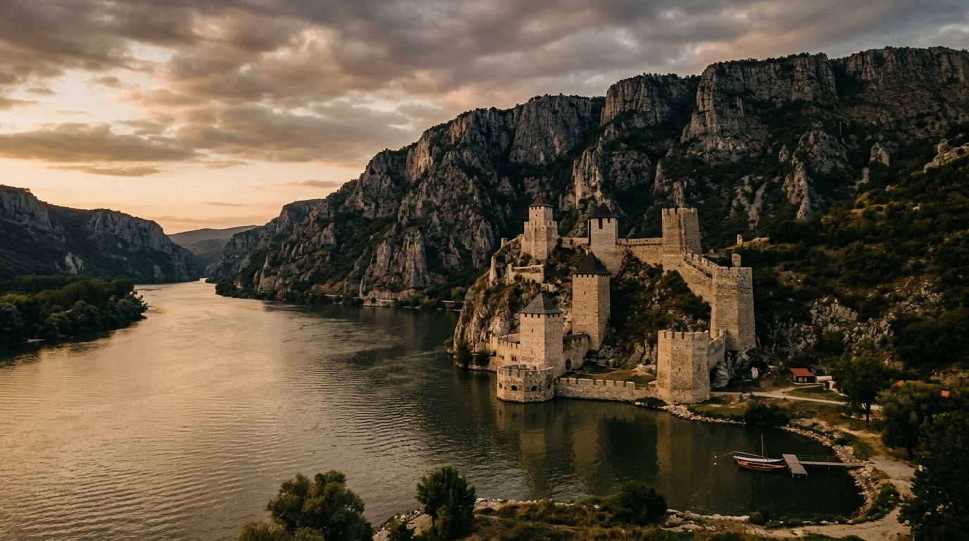
Golubac Fortress
Golubac Fortress is the gateway to the gorge and one of the most dramatically positioned castles in Europe. It sits at the point where the Danube narrows from a wide lowland river into the gorge, its nine towers rising from a rocky promontory directly above the water. The fortress was contested by Serbs, Hungarians, Bulgarians, and Ottomans over five centuries – everyone wanted to control this chokepoint.
The fortress was comprehensively restored in 2019 and is now a proper museum with multimedia exhibits, walkways along the ramparts, and explanatory panels in Serbian and English. The restoration is well done – they resisted the urge to over-sanitize it.
| Golubac Fortress | |
|---|---|
| Entry fee | RSD 600 (~EUR 5) |
| Opening hours | 10:00-18:00 (summer), shorter in winter |
| Time needed | 1-1.5 hours |
| Parking | Large free lot 200m before the fortress entrance |
The views from the upper towers are the reward – the Danube stretching east into the gorge, the Romanian shore opposite, and the Carpathian foothills fading into the distance. On a clear day, you can see the river winding for kilometers.
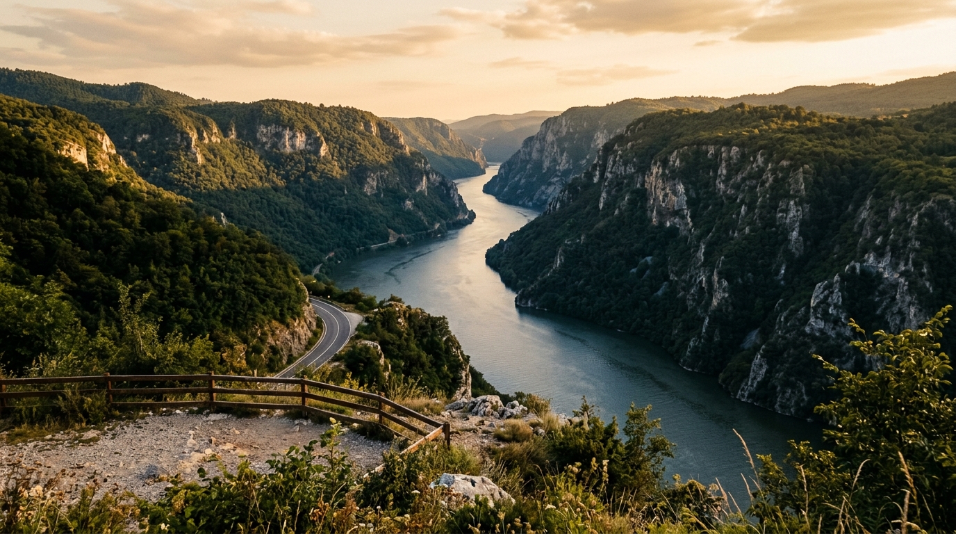
Into the Gorge
From Golubac, the road enters the gorge proper and the character of the drive changes completely. The Danube narrows, the cliffs rise on both sides, and the road clings to the Serbian bank with the river on your right and limestone walls on your left. This section is narrow – two lanes, no shoulder, occasional tunnels – and requires attention. The road surface is good but the curves are tight and sightlines are limited.
The gorge has four distinct sections, each with its own character:
| Section | Length | Character |
|---|---|---|
| Golubac Gorge | 14 km | Wide river, fortress views |
| Ljupkovska Gorge | 2 km | Narrowest point, dramatic cliffs |
| Kazan (The Cauldron) | 8 km | River at its narrowest (150m), highest cliffs |
| Sipska Gorge | 15 km | Opens toward the dam |
Kazan – “the Cauldron” – is the most dramatic section. The river narrows to just 150 meters wide while reaching depths of over 80 meters. The cliffs on both sides rise to 300 meters. You will want to stop, and there are a few pull-offs cut into the rock, though they fill quickly in summer.
The Djerdap Gorge is where the Danube decides to stop being a polite Central European river and start acting like it has something to prove.
Donji Milanovac
Midway through the gorge, the town of Donji Milanovac sits in a small bay where the river briefly widens. This is the practical base for exploring the gorge – the town has hotels, restaurants, and a waterfront promenade.
The original town was flooded when the Iron Gates dam was built in 1972. The current Donji Milanovac was built on higher ground to replace it, which gives the town a slightly planned, 1970s feel. It is not picturesque, but it is functional and friendly.
Where to stay: Hotel Lepenski Vir (RSD 5,000-8,000 / EUR 42-68 per night for a double) has river views and a restaurant. Several guesthouses (RSD 2,500-4,000 / EUR 21-34) are available along the waterfront. Book ahead in July-August.
Where to eat: The waterfront restaurants serve Danube fish – pike-perch, catfish, and carp, often grilled or baked in a clay pot. A fish dinner with wine runs RSD 1,500-2,500 (EUR 13-21) per person.
Lepenski Vir
This is the drive’s intellectual highlight. Lepenski Vir is an archaeological site dating to approximately 7000-6000 BC – a Mesolithic settlement on the Danube bank where a community of fishermen built trapezoidal houses, sculpted stone figures with human-fish hybrid faces, and maintained a sophisticated culture for over a millennium.
The settlement challenges the standard narrative of prehistoric Europe. These were not primitive cave-dwellers but a community with architecture, art, and a settled lifestyle that predates agriculture in this region. The stone sculptures – boulders carved with large, staring eyes and fish-like mouths – are unlike anything else from this period anywhere in the world.
The museum is modern, well-designed, and built over the original excavation site. You walk on a raised platform above the foundations of the houses, which are preserved where they were found. The sculptures are displayed in a climate-controlled gallery.
| Lepenski Vir Museum | |
|---|---|
| Entry fee | RSD 500 (~EUR 4.30) |
| Opening hours | 9:00-17:00 (closed Mondays) |
| Time needed | 1-1.5 hours |
| Parking | Free lot at the entrance |
| Audio guide | Available in English, recommended |
Tip: The original site was moved to higher ground before the dam flooded its original location. What you see is the relocated settlement, but the foundations and sculptures are genuine artifacts, not reproductions.
Tabula Traiana
Ten kilometers downstream from Lepenski Vir, a Roman inscription is carved into the cliff face above the Danube. The Tabula Traiana commemorates the completion of Trajan’s military road through the gorge in 100 AD – a road carved into the cliff walls to allow Roman legions to move along the Danube toward Dacia (modern Romania).
The inscription is visible from a viewing platform reached by a short walk from a roadside parking area. The text, in Latin, reads: “Emperor Caesar Nerva Trajan… conquered the mountain and the river and opened this road.” The Roman road itself – traces of which are visible in the cliff face below the waterline – was one of the most ambitious engineering projects of the ancient world.
This is a 15-minute stop, but a memorable one. There is something humbling about standing in front of a 1,900-year-old inscription that essentially says “we were here, and we built a road through this impossible gorge.”
Iron Gates Dam
The eastern end of the gorge is closed by the Djerdap Dam, also known as the Iron Gates Dam – a joint Serbian-Romanian hydroelectric dam built between 1963 and 1972. It was the largest dam on the Danube at the time and remains one of the largest in Europe, producing enough electricity to power most of Serbia.
The dam itself is not open to public tours (it is a working power plant and a border installation), but you can view it from the Serbian side at a signed viewpoint near Kladovo. The sheer scale is impressive – 1,278 meters long, 60 meters high, with the Danube backing up behind it into a reservoir that extends 270 km upstream.
Kladovo, the town at the dam, is the end point of the gorge drive. It is a quiet border town with a small archaeological museum (Roman ruins from Diana fortress) and a functioning ferry crossing to Romania.
Practical Information
Road Conditions
The road through Djerdap Gorge is a two-lane asphalt road in generally good condition. Key considerations:
- Width: Narrow in sections, with no shoulder. Passing trucks requires care.
- Tunnels: Several short tunnels, adequately lit. Use headlights.
- Speed: The posted limit is 60-80 km/h through the gorge, which matches what the road allows. Some locals drive faster. Let them pass.
- Winter: The road is open year-round but can be icy from December through February, especially in shaded gorge sections. Snow chains are recommended in winter.
A standard car is perfectly fine for the entire route.
Best Time to Visit
- May-June: Green hills, comfortable temperatures, the Danube running strong from spring snowmelt. Our recommendation.
- July-August: Warm (30+ degrees), busy with domestic tourists, but the long days give you more time for stops. Book accommodation in Donji Milanovac in advance.
- September-October: Autumn color in the gorge, fewer visitors, excellent light for photography.
- November-April: Cold and often grey, but atmospheric. The gorge in winter fog has a melancholy beauty. Some tourist facilities close for the season.
Fuel
Fill up in Veliko Gradiste or Golubac before entering the gorge. Donji Milanovac has a fuel station. Kladovo has stations at the eastern end. The gorge section between Golubac and Donji Milanovac has no fuel stations – the distance is only 40 km, so this is not a range issue for any car, but do not start the drive on fumes.
Combining with Other Trips
The Djerdap Gorge connects naturally with several other routes:
- From Belgrade: Combine with one of the Belgrade day trips – drive to Smederevo (45 km from Belgrade), continue east along the Danube to Golubac (additional 100 km), and enter the gorge.
- To Romania: Cross the Danube at Kladovo by ferry or drive south to the Negotin crossing. From there, you can reach Transylvania in about 4-5 hours.
- Loop back to Belgrade: From Kladovo, drive south to Negotin and then west through Zajecar and Paracin back to the E75 motorway (about 4 hours to Belgrade). This loop gives you the gorge in one direction and central Serbian highlands in the other.
For toll information, speed limits, and insurance details, see our Serbia driving guide. For the border crossing into Romania, check our border crossings guide.