Vrsic Pass Driving Guide
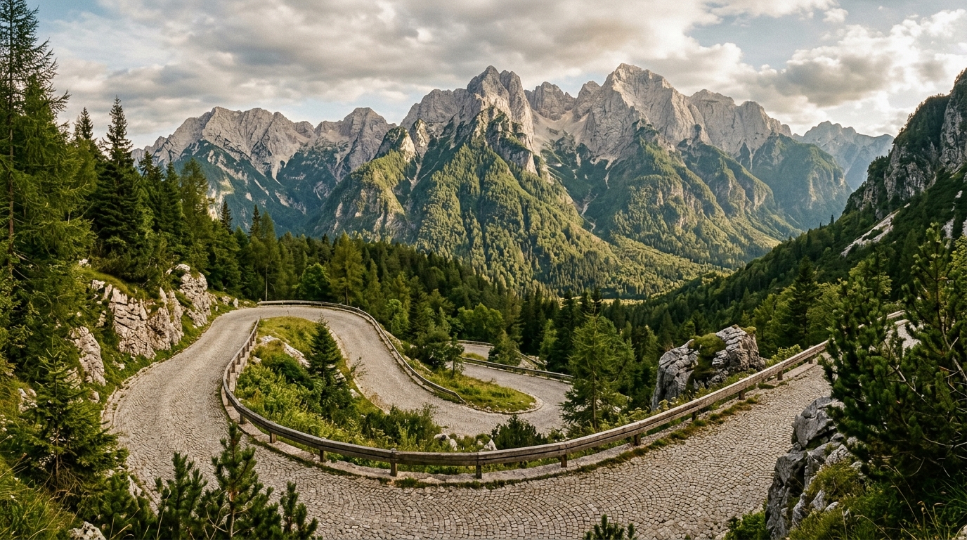
The Vrsic Pass is a road that announces its intentions from the first hairpin. Fifty numbered turns – twenty-four climbing up from Kranjska Gora, twenty-six descending toward Bovec – each one cobblestoned, each one tighter than seems reasonable, and each one delivering a view of the Julian Alps that makes you forget you are steering a vehicle up a mountainside on wet rocks built by Russian prisoners of war in 1916. This is Slovenia’s most dramatic mountain road, and it is not trying to be convenient. It is trying to be unforgettable.
The pass connects Kranjska Gora in the north (ski resorts, proximity to Austria and Italy) with Bovec in the south (the Soca Valley, whitewater rafting, alpine scenery that feels Patagonian). At 1,611 meters, it is the highest paved pass in Slovenia. The road was built during World War I as a supply route for the Austro-Hungarian army, and the history is literally carved into every cobblestone. We have driven it in sun, in rain, and once in early October with frost on the stones. The drive is always memorable. The conditions determine whether “memorable” is a compliment.
Route Overview
| Detail | Information |
|---|---|
| Route | Kranjska Gora to Bovec (or reverse) |
| Distance | ~50 km |
| Drive time | 1.5-2 hours (no stops) |
| Summit altitude | 1,611 m |
| Numbered hairpins | 50 (24 north side, 26 south side) |
| Road surface | Mix of cobblestone (hairpins) and asphalt (straights) |
| Open season | Typically May to October/November |
| Toll | None |
| Fuel | Fill up in Kranjska Gora or Bovec – none on the pass |
The road is officially closed in winter (roughly November through April, depending on snowfall). Check current status at promet.si (Slovenian road conditions website) before driving.
The North Side: Kranjska Gora to the Summit
Kranjska Gora is a small alpine town near the Italian and Austrian borders, primarily known as a ski resort. In summer it is quiet, clean, and serves as the natural staging point for the Vrsic Pass. Fill your tank here – the next fuel station is in Bovec, 50 km and roughly 2 hours away.
The climb begins at the southern edge of town. The first few hairpins are gentle, winding through dense spruce forest. By hairpin 5 or 6, the road’s character becomes clear: the turns are cobblestoned (the original WWI surface, maintained but not modernized), the gradient steepens, and the forest begins to thin.
The Cobblestones
The Vrsic cobblestones deserve their own paragraph because they will occupy your full attention. They are not decorative. They are functional, original, and in wet conditions they are slippery enough to make your tires question their life choices. The technique is straightforward: go slow, stay in second gear, avoid braking on the cobblestones themselves, and do your braking on the asphalt sections between turns.
In dry conditions, the cobblestones are merely bumpy and atmospheric. In rain, they demand respect. We drove the pass once after a morning shower and spent the entire north side in first gear, which is not fast but is alive.
Tip: If the cobblestones worry you, drive the pass in the morning when they are most likely to be dry. Afternoon mountain showers are common in summer. And if you find yourself behind a slower vehicle on the cobblestones, do not attempt to overtake on the hairpins. The road is too narrow and the visibility is zero.
Russian Chapel (Ruska Kapelica)
At hairpin 8, a small wooden chapel stands beside the road. This is the Russian Chapel (Ruska Kapelica), built to commemorate the Russian prisoners of war who were forced to construct the Vrsic road for the Austro-Hungarian army during World War I. In March 1916, an avalanche killed between 200 and 300 Russian prisoners at this spot while they were working on the road.
The chapel is small, wooden, and deeply affecting. It was built by surviving prisoners and has been maintained by Slovenian and Russian governments since. Stop here. It takes five minutes to walk around and read the memorial plaques, and it provides context that transforms the rest of the drive from a scenic route into a road with a story.
Free parking for 5-6 cars at the chapel. In summer, the lot fills quickly – arrive early or wait for a spot.
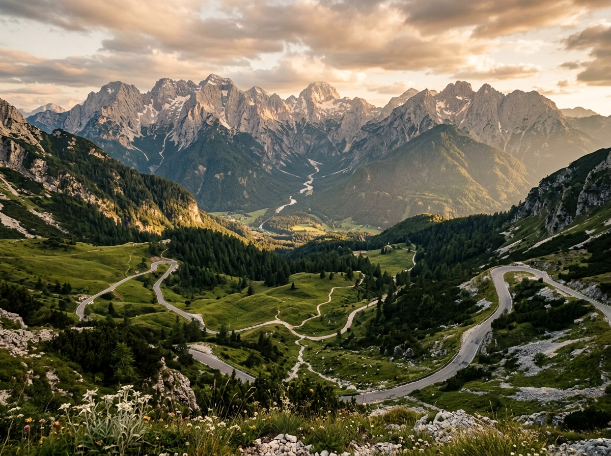
The Summit
At 1,611 meters, the Vrsic summit is a broad saddle between peaks with a parking area, a mountain hut (Ticnikov Dom), and panoramic views in every direction. On a clear day, you can see Mount Triglav – Slovenia’s highest peak at 2,864 meters – rising to the west.
| Summit Facilities | |
|---|---|
| Parking | Free, medium-sized lot (fills by midday in summer) |
| Ticnikov Dom | Mountain hut: drinks, simple meals, basic rooms |
| Toilets | At the mountain hut (paid, EUR 0.50) |
| Hiking trails | Multiple routes from the summit – Slemenova Spica (1 hour), Prisojnik (3 hours) |
The summit is a natural break point. Have a coffee at Ticnikov Dom (a proper Slovenian mountain hut with wood-paneled interior and functional food), stretch your legs, and take in the view before beginning the descent.
For hikers, the trail to Slemenova Spica (1,911 meters, about 1 hour from the summit) is a manageable addition that offers a wider panorama without requiring technical skills. The trail to the Prisojnik Window (Okno) – a natural rock arch near the summit of Mount Prisojnik – is more demanding (3 hours round trip, steep, requires some scrambling) but spectacular.
The South Side: Summit to Bovec
The south side of the Vrsic Pass has 26 numbered hairpins (numbered downward from 26 to 1) and is generally considered the more dramatic of the two sides. The descent is steeper, the views into the Trenta valley are more open, and the transition from bare alpine terrain to deep valley forest is more abrupt.
The cobblestones continue on the south side, with the same wet-weather cautions. Descending on cobblestones is harder on the brakes than ascending – use engine braking in low gear and keep a steady, unhurried pace.
Ajdovscina Window (Ajdovska Deklica)
On the south side, look for the rock face above the road near hairpin 15-16. A natural formation in the limestone resembles a human face in profile – the Ajdovska Deklica (Pagan Girl). Slovenian folklore holds that she was a pagan maiden turned to stone. A viewing platform and small parking area are signed.
Soca River Source
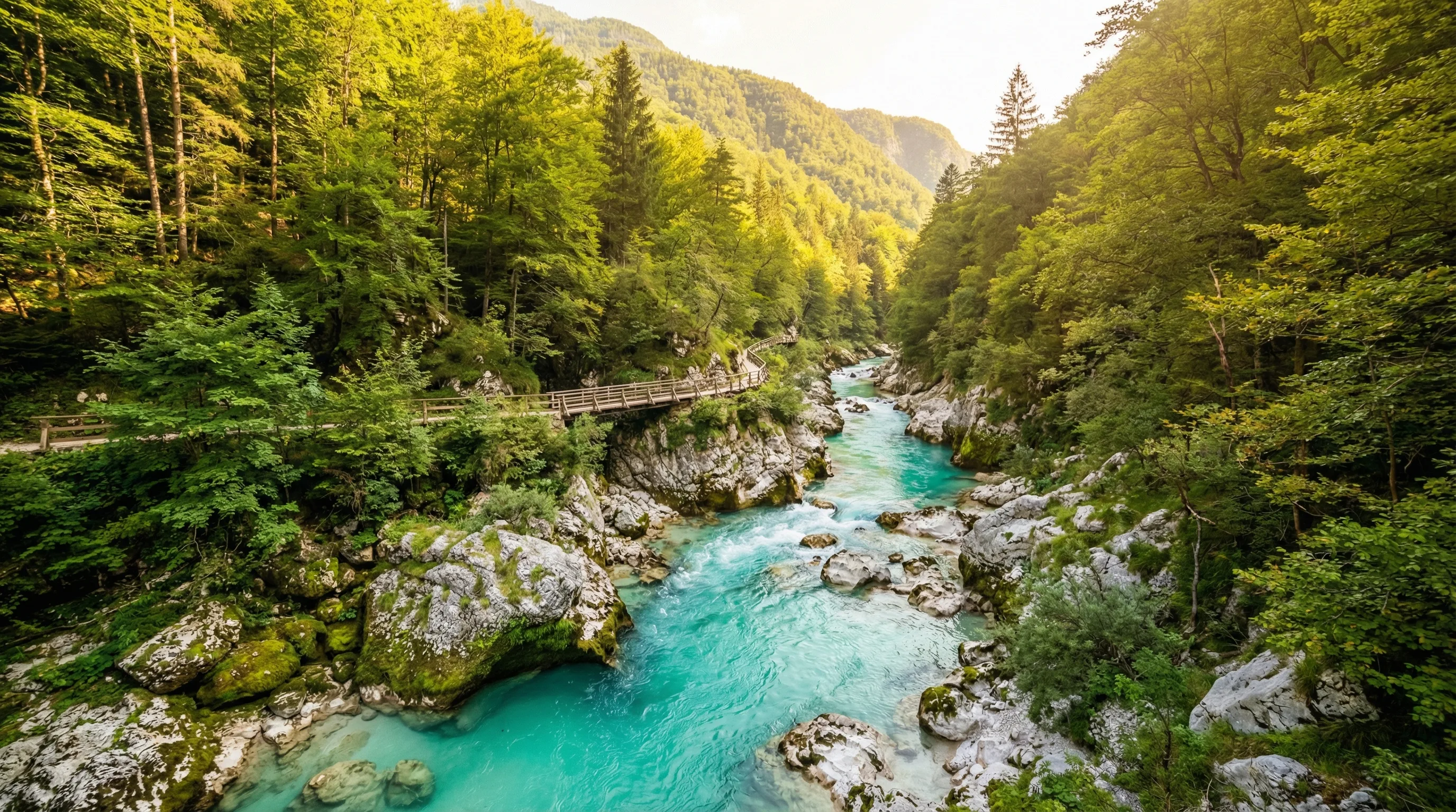
Near the bottom of the south side, a signed trail leads to the source of the Soca River – a spring emerging from a rock wall at the base of a cliff. The water is an extraordinary shade of blue-green that Slovenians have trademarked in spirit if not in law. The trail is a 20-minute walk from the parking area.
The Soca (known as the Isonzo in Italian) runs south through the Trenta valley and eventually through Bovec, and its emerald color becomes the defining feature of the landscape for the rest of your drive through western Slovenia.
Arriving in Bovec
The road straightens as you enter the Soca Valley and reach Bovec, an adventure sports town surrounded by the Julian Alps. Bovec is the whitewater rafting capital of Slovenia (and possibly the Balkans), and the town’s economy runs on adrenaline tourism from May through September.
From Bovec, your options open up:
| From Bovec | Distance | Time | Notes |
|---|---|---|---|
| Kobarid (WWI museum) | 20 km | 25 min | Outstanding WWI museum, Hemingway connection |
| Tolmin Gorge | 40 km | 40 min | Narrow gorge, easy walk |
| Nova Gorica (Italian border) | 80 km | 1.5 hours | Soca Valley road, wine country |
| Ljubljana | 130 km | 2 hours | Via Idrija or over the Predel Pass |
| Lake Bled | 100 km | 2 hours | Via Vrsic (back over the pass!) or around via Tolmin |
The Soca Valley road from Bovec south to Kobarid and beyond is arguably as beautiful as the Vrsic Pass itself – just gentler. The emerald river, the WWI history, and the alpine meadows make this stretch of western Slovenia feel like a different country from Ljubljana.
The Alternative: Predel Pass
If the Vrsic Pass sounds intimidating, the Predel Pass offers a gentler alternative for crossing from the north side to the Soca Valley. The Predel Pass (1,156 meters) runs from Kranjska Gora southwest to Log pod Mangartom, connecting to Bovec via a valley road.
| Vrsic Pass | Predel Pass | |
|---|---|---|
| Summit altitude | 1,611 m | 1,156 m |
| Hairpins | 50 (cobblestone) | Moderate curves (asphalt) |
| Drive time (Kranjska Gora to Bovec) | 1.5-2 hours | 1.5 hours |
| Difficulty | Moderate-challenging | Easy |
| Scenery | Alpine, dramatic, intense | Pleasant, less dramatic |
| Open season | May-October | Year-round (may require chains in winter) |
The Predel Pass is a perfectly fine road. It is just not the Vrsic Pass.
Practical Information
What to Drive
Any car can drive the Vrsic Pass, but some are better suited than others:
- Manual transmission: More control on the cobblestones. Our preference.
- Automatic transmission: Fine, but the transmission may hunt between gears on the steep sections.
- Low-clearance sports cars: Not ideal. The cobblestones are uneven and some road edges have rough transitions.
- Campervans/large vehicles: Technically allowed but stressful. The hairpins are tight and visibility is limited. Vehicles over 7 meters will struggle.
Weather
Mountain weather at 1,611 meters changes fast. Assume the summit will be 10-15 degrees colder than the valley floor. Bring a jacket even in July. Morning fog is common and can reduce visibility to a few meters at the summit. Afternoon thunderstorms in summer are frequent.
If conditions deteriorate seriously (heavy rain, fog, snow), pull over and wait. The pass is not a place to push through poor visibility.
Safety
The Vrsic Pass has guardrails on most hairpins and is regularly driven by tour buses, motorcycles, and cyclists. It is not dangerous, but it demands attention:
- Speed: 20-30 km/h on the hairpins. No exceptions.
- Oncoming traffic: The road is narrow. Yield to uphill traffic where sight lines are short.
- Cyclists: The Vrsic is a popular cycling climb. Give them space and patience. They are working harder than you are.
- Motorcycles: Common, usually respectful. Watch for the occasional fast rider.
Best Time
- June-September: Optimal. Long days, generally dry (though afternoon showers are always possible), all facilities open.
- May and October: The pass may be open but conditions are colder, facilities may be closed, and the cobblestones are more likely to be wet or icy.
- Winter: Closed. The Predel Pass is your alternative.
For general Slovenia driving information – vignette system, speed limits, insurance – see our Slovenia hub page and the driving guide. For a complementary drive in western Slovenia, see our Ljubljana to Bled and Bohinj guide.