Sarajevo to Mostar Drive
The M17 from Sarajevo to Mostar is the drive that made us fall in love with Bosnia. One hundred and thirty kilometers of two-lane road through the Neretva canyon, where the river runs a shade of green that looks like someone spilled antifreeze into a postcard. We have driven this route at least a dozen times, and it has never once felt routine. The road hugs the river, ducks through tunnels carved into raw limestone, passes Ottoman bridges that have been standing since before Columbus left port, and deposits you in Mostar just in time for the afternoon light to hit the Old Bridge. It takes about two and a half hours without stops. Nobody drives it without stops.
This is not a highway in any modern sense. The M17 is a two-lane road shared with trucks, tour buses, and locals who know every curve by heart. The scenery compensates for everything. If you only have time for one drive in the entire Balkans, this is a strong candidate.
Route Overview
| Segment | Distance | Drive Time | Highlights |
|---|---|---|---|
| Sarajevo to Konjic | 60 km | 1 hour | Mountain pass, Konjic Ottoman bridge |
| Konjic to Jablanica | 25 km | 25 min | Neretva canyon narrows, WWII museum |
| Jablanica to Blagaj | 30 km | 30 min | Canyon opens, Buna River source |
| Blagaj to Mostar | 12 km | 15 min | Tunnel system, arrival at Stari Most |
| Total | ~130 km | ~2.5 hours |
The times above assume no stops and reasonable traffic. In summer, add 20-30 minutes for congestion approaching Mostar and slower vehicles on the canyon road. In winter, the route is open year-round but can be icy on the mountain pass between Sarajevo and Konjic.
Leaving Sarajevo
Head south from central Sarajevo on the M18, which becomes the M17 as you leave the city. The road climbs out of the Sarajevo basin through Ilidza – where Archduke Franz Ferdinand took his fatal wrong turn in 1914, though the city has moved on – and up into the mountains toward Ivan Sedlo pass (967 meters).
The pass itself is not dramatic in the Alpine sense, but it marks the transition from the Sarajevo plateau to the Neretva watershed. On a clear morning, the views south toward the canyon system are worth a brief roadside pause. There are a couple of pull-offs near the summit with enough room for 3-4 cars.
Tip: Fill your tank in Sarajevo before leaving. Fuel stations along the M17 exist but are less frequent in the canyon section between Konjic and Jablanica. Prices are similar everywhere in Bosnia (around BAM 2.50/L for petrol), so there is no strategic advantage to waiting.
Stop 1: Konjic
| Distance from Sarajevo: 60 km | Drive time: ~1 hour |
Konjic is a small town on the Neretva that most people drive through without realizing what they are missing. The six-arched Ottoman bridge (Stara Cuprija) spanning the Neretva is a 17th-century original – rebuilt after WWII damage, but faithful to the original design. Park on the main road near the bridge (free, informal spots along the riverbank) and walk down to the water level for the best angle.
The town also hides one of the Cold War’s strangest secrets: Tito’s nuclear bunker (ARK D-0), built into the mountain outside town between 1953 and 1979. It was designed to shelter 350 Yugoslav leaders in case of nuclear attack and was kept classified until 2011. Tours run daily (BAM 20 / ~EUR 10, 1 hour), but you need to book ahead in summer. The bunker is a 15-minute drive from the town center on a marked turnoff.
Beyond the bunker, Konjic is where traditional woodcarving (Konjic woodcarving is on the UNESCO Intangible Heritage list) has been practiced for centuries. A couple of workshops near the old town sell handmade pieces if you want something more meaningful than a fridge magnet.
Time needed: 30 minutes for the bridge, 1.5 hours if you add the bunker.
Stop 2: Jablanica
| Distance from Konjic: 25 km | Drive time: ~25 minutes |
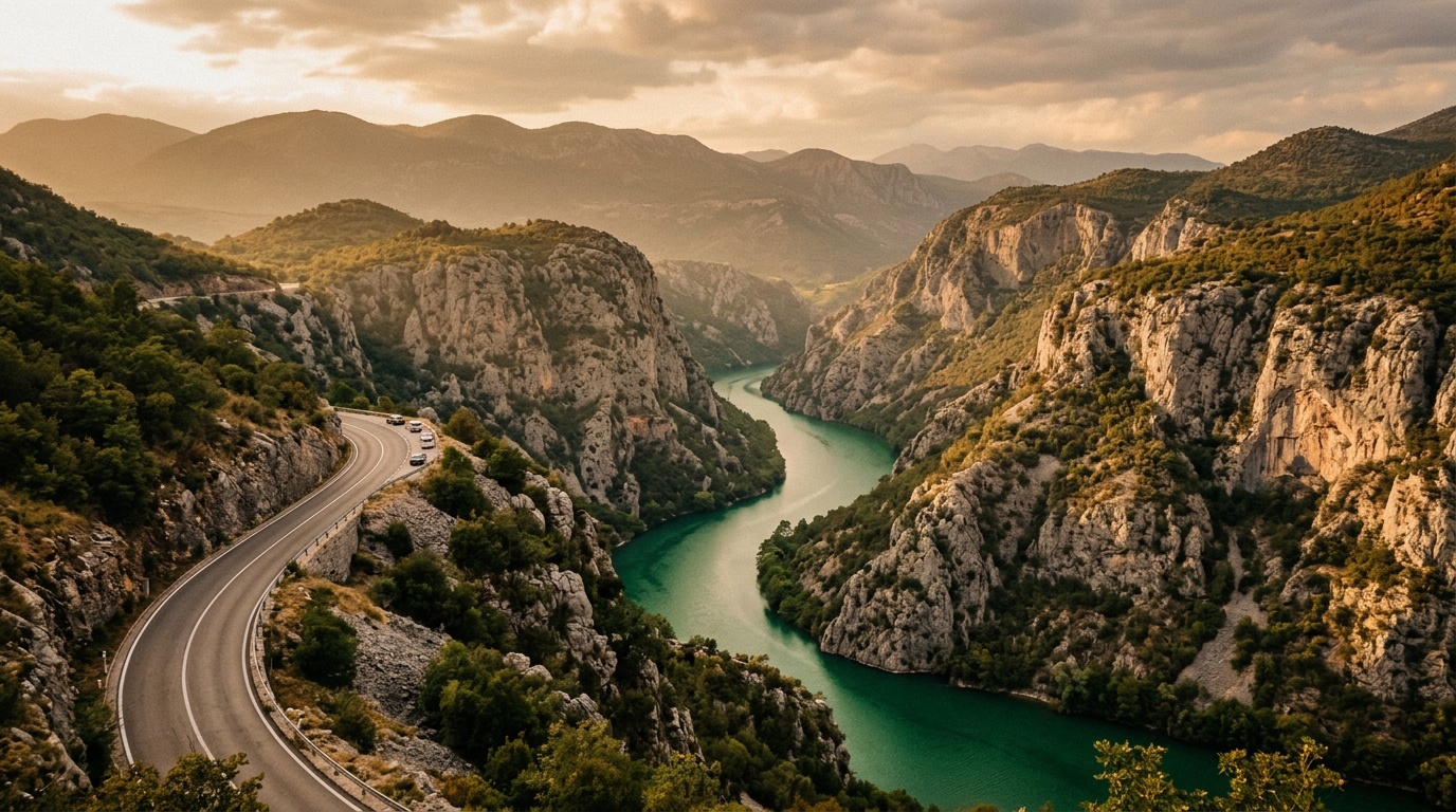
The road from Konjic to Jablanica runs along the Neretva as the canyon tightens. This stretch is where the drive starts to feel serious – limestone walls closing in on both sides, the river running fast below, and the road threading through a sequence of short tunnels and cliff-side curves. Drive with your lights on and give trucks wide berth in the tunnels.
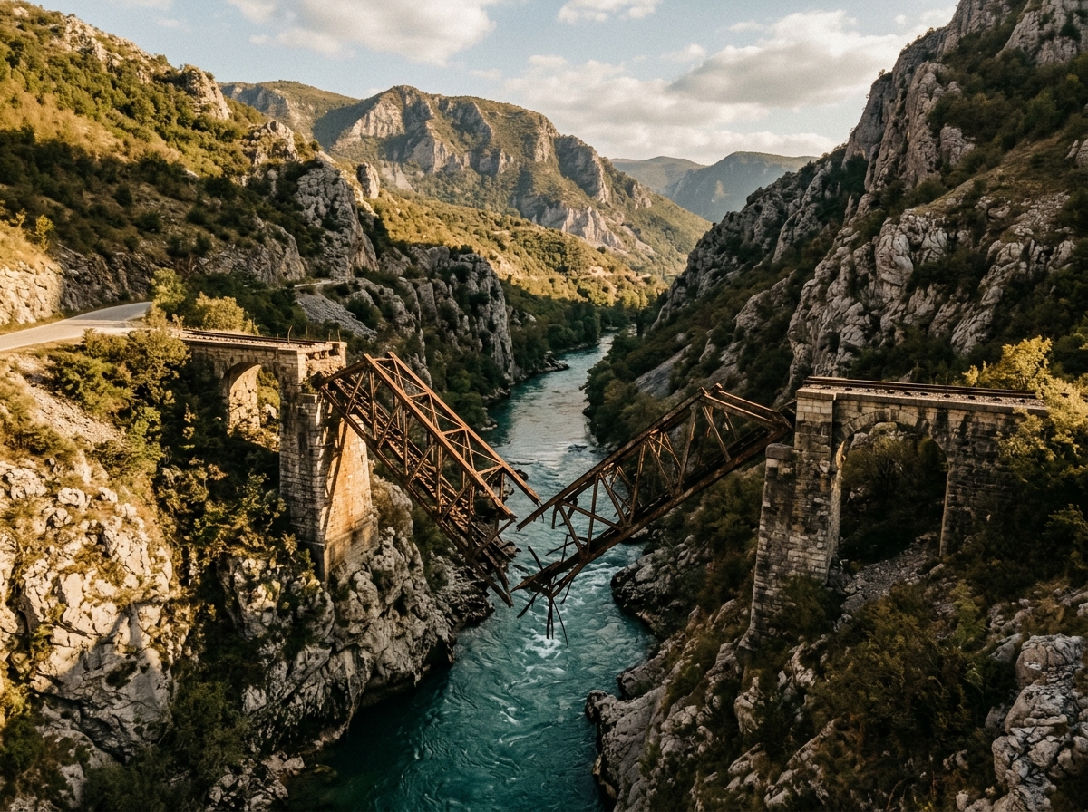
Jablanica itself is a junction town with one major attraction: the Museum of the Battle of the Neretva. In 1943, Yugoslav Partisans destroyed the railway bridge here to prevent a German advance – a moment dramatized in the 1969 film “The Battle of Neretva” starring Yul Brynner and Orson Welles. The destroyed bridge is still visible in the gorge, and the museum (BAM 5 / ~EUR 2.50) has weapons, photographs, and a model of the battle. It is a 30-minute visit, longer if you find WWII Partisan history as compelling as we do.
The museum is right next to the road and well-signed. Parking is in a small lot beside the building.
More practically, Jablanica is where the canyon section of the M17 begins in earnest. From here to Mostar, the Neretva drops through a series of increasingly dramatic gorges. The road quality is decent – paved, lined, and maintained – but the curves are tight and the trucks are wide. Overtaking opportunities are limited to the rare straight section.
The M17 through the Neretva canyon is the kind of road that makes passengers religious and drivers attentive. Both reactions are appropriate.
Stop 3: Blagaj
| Distance from Jablanica: 30 km | Drive time: ~30 minutes |
Just before reaching Mostar, turn off the M17 at the signed exit for Blagaj. This 12-kilometer detour is not optional. Blagaj is where the Buna River emerges fully formed from a cave at the base of a 200-meter cliff. Perched against the cliff face is the Blagaj Tekke (Tekija), a 16th-century Dervish monastery that looks like it was built by someone who wanted to win an argument about dramatic locations.
The Tekke is open to visitors (BAM 5 / ~EUR 2.50). Remove your shoes at the entrance. The interior is modest – carpeted prayer rooms, low ceilings, the sound of the river echoing through the stone walls. The real draw is the setting: the turquoise river, the cave mouth, the cliff, the white stone building. Photographers will lose 30 minutes here without noticing.
| Blagaj Practical Info | |
|---|---|
| Parking | Small lot at the entrance, BAM 3 (~EUR 1.50) |
| Tekke entry | BAM 5 (~EUR 2.50) |
| Restaurants | Several along the river, grilled trout is the local specialty |
| Time needed | 45 min to 1.5 hours |
The restaurants along the Buna serve trout pulled from the river that morning. Prices are lower than Mostar (a full trout meal with sides runs BAM 15-20 / EUR 8-10). If you are going to eat lunch on this drive, this is the place.
From Blagaj, follow the road south and it connects back to the M17 approach into Mostar, or take the smaller road directly into Mostar’s east side.
The Tunnel System Before Mostar
The last section of the M17 before Mostar passes through a series of tunnels – some short, some long enough that you lose daylight for a while. These tunnels are functional rather than charming: lighting is adequate but not generous, the road narrows slightly, and oncoming headlights can be momentarily disorienting.
The tunnels were strategically significant during the 1990s war, and some bear visible damage that has been patched rather than fully repaired. They are safe for driving but serve as a quiet reminder that this route has seen more than tourist traffic.
After the last tunnel, the road descends into the Mostar basin and the city opens up ahead. Follow signs for “Centar” and the Stari Most (Old Bridge) area.
Arriving in Mostar
Park before you reach the Old Town. The streets near Stari Most are pedestrian-only, and the access roads are narrow one-way corridors designed for a time when cars had not been invented. Your best options:
| Parking Area | Distance to Stari Most | Cost | Notes |
|---|---|---|---|
| Parking Onescu (east bank) | 5 min walk | BAM 5/day | Largest lot, well-signed |
| HIT parking (west bank) | 8 min walk | BAM 3-5/day | Near the Gymnasium |
| Lucki Most parking | 3 min walk | BAM 5/day | Closest, fills up early in summer |
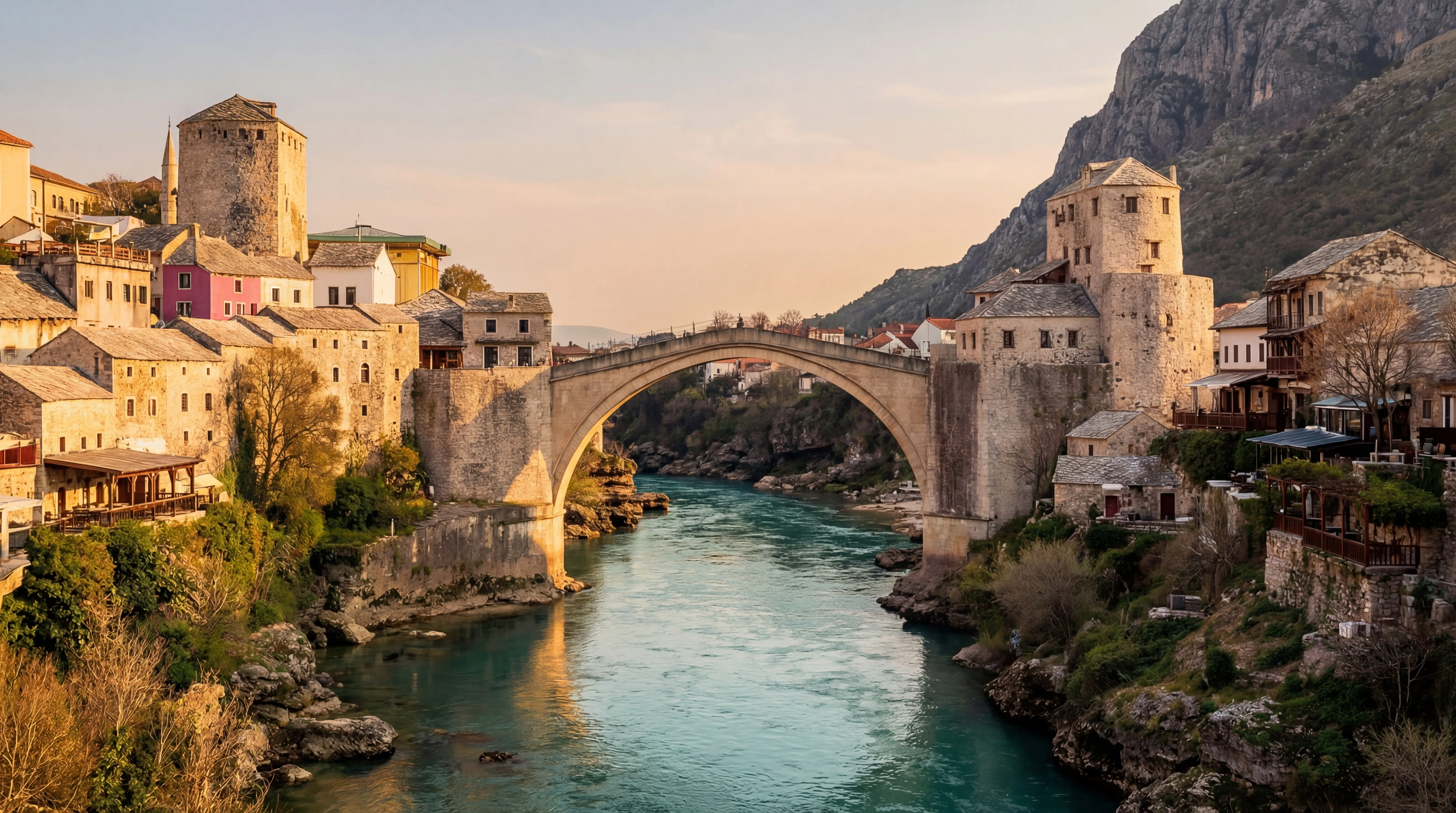
Stari Most (the Old Bridge): The Ottoman bridge was built in 1566, destroyed by Croatian forces in 1993, and rebuilt from the original stone in 2004 using recovered blocks from the Neretva. It is a UNESCO World Heritage Site, and it is genuinely moving – both as an architectural achievement and as a symbol of destruction and reconstruction.
Walk across the bridge, watch the divers (local men jump from the 24-meter bridge into the Neretva for tourist tips, a tradition that dates back to the 17th century), and explore the old town on both banks. The bazaar on the east side sells the usual copper coffee sets and scarves, but the craftsmanship is real – Mostar’s coppersmiths are still working.
Budget 2-3 hours for Mostar’s old town. If you have more time, cross the Neretva to the west bank and walk through the neighborhoods that show more war damage and less restoration. This is where Mostar’s complexity becomes visible – the city is not a simple fairy tale.
Return Option: The Prozor Alternative Route
If you are driving back to Sarajevo and want to see different scenery, consider the Prozor-Rama route instead of retracing the M17. This adds about 30-40 minutes to the drive but takes you through the central Bosnian highlands.
| Route | Distance | Time | Character |
|---|---|---|---|
| M17 (return same way) | 130 km | 2.5 hours | Canyon, familiar, reliable |
| Via Prozor-Rama | 170 km | 3-3.5 hours | Mountain plateaus, Rama Lake, fewer trucks |
The Prozor route heads north from Mostar through Jablanica (you will pass the museum again), then turns northeast on the M16.2 through Prozor-Rama. Rama Lake (Ramsko Jezero) is a large artificial lake surrounded by mountains – a good stop for photos and possibly a coffee at one of the lakeside cafes. The road continues north through the highland plateau past Fojnica and back into Sarajevo from the west.
Road quality on the Prozor route is slightly rougher than the M17 but perfectly manageable in a standard car. Traffic is lighter, and the landscape shifts from river canyon to mountain plateau – broader views, fewer tunnels, more sky.
Practical Information
Best Time to Drive
The M17 is open year-round, but the experience changes with the season:
- May-June: The Neretva runs high and fast, the canyon is green, temperatures are comfortable. Our favorite time.
- July-August: Hot (35+ degrees in Mostar), heavy tourist traffic, parking in Mostar is a challenge. Start early.
- September-October: Warm, crowds thin, the light turns golden. Excellent.
- November-March: Cooler, occasional snow on the Ivan Sedlo pass (carry chains just in case), almost no tourists. The canyon is atmospheric in grey weather.
Road Conditions
The M17 is a well-maintained two-lane road. Asphalt is in good condition throughout. The main challenges are:
- Trucks: Slow-moving trucks in the canyon section between Jablanica and Mostar. Overtaking requires patience and visibility.
- Tunnels: Some are poorly lit. Use headlights.
- Summer traffic: Congestion builds approaching Mostar, especially on weekends.
- Winter: Possible ice on Ivan Sedlo pass. The canyon section rarely freezes due to the sheltered terrain.
Fuel
Fill up in Sarajevo or Mostar. Stations exist along the route but are sparse in the canyon section. Konjic and Jablanica both have stations. Prices are consistent across Bosnia at roughly BAM 2.50/L (~EUR 1.28) for petrol.
Combining With Other Routes
The Sarajevo-to-Mostar drive connects naturally with several other itineraries:
- From Mostar, continue south to the Croatian border and Dubrovnik (140 km, 2.5 hours)
- From Mostar, head southeast to Montenegro via Trebinje (170 km, 3 hours)
- From Sarajevo, head north toward Serbia via Zvornik or west toward the Una National Park (4 hours)
For speed limits, required equipment, and insurance details, see our Bosnia driving guide and general driving guide.