Bay of Kotor Driving Guide
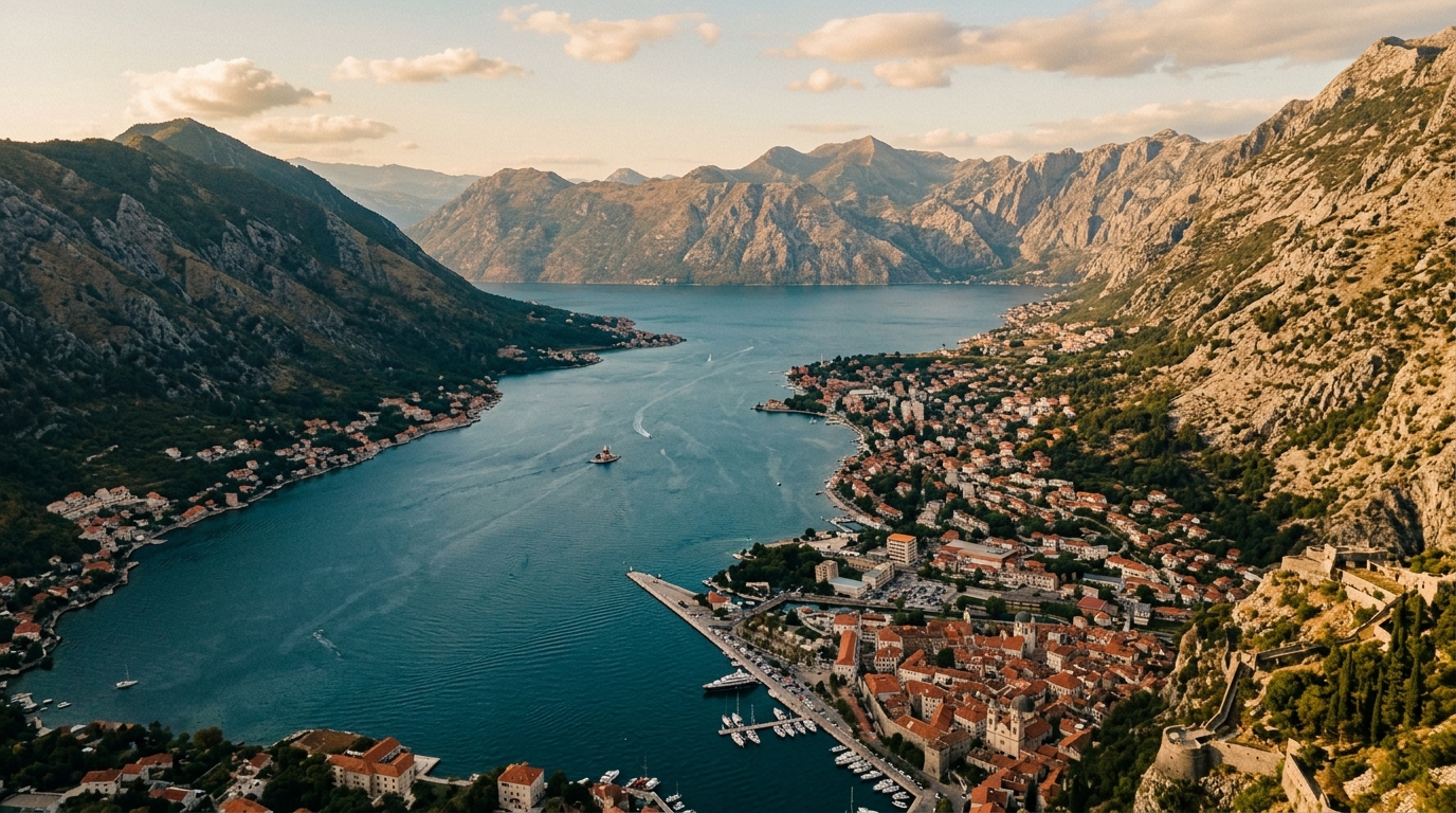
The Bay of Kotor is what happens when geology decides to show off. A fjord-like inlet cuts 28 km into the Montenegrin coast, surrounded by mountains that rise over 1,000 meters straight from the waterline. Medieval towns cling to the shore at every bend. The road hugs the water so closely that in some stretches you could roll down your window and touch the bay. We have driven this loop a dozen times, and we still pull over at least twice each trip — not because we need directions, but because the view from the next corner is somehow better than the last one.
The full loop around the bay is about 80 km and takes 2-3 hours of actual driving. With stops — and you will stop — plan for half a day minimum. A full day is better. The route works as a standalone experience or as part of the Adriatic Coast route from Dubrovnik to Tirana. Either way, this is the single drive in Montenegro that you cannot afford to rush.
The Loop: Counterclockwise Is Better
You can drive the bay in either direction, but we recommend counterclockwise: start in Kotor, drive south along the eastern shore to Tivat, cross the bay by road or ferry, then follow the western shore through Perast and Herceg Novi back to the Croatian border or loop back to Kotor.
Why counterclockwise? Three reasons. First, you stay on the water side of the road, which means better views and easier photo stops without crossing traffic. Second, you hit Perast in the afternoon when the light on the two islands is at its best. Third, if you plan to take the ferry across the narrows, you approach it from the less-congested direction.
Route Summary
| Segment | Distance | Drive Time | Key attraction |
|---|---|---|---|
| Kotor to Tivat | 12 km | 20 min | Porto Montenegro marina |
| Tivat to Lepetane ferry | 8 km | 10 min | Bay views |
| Ferry crossing | 1 km | 10 min | The ferry itself is the attraction |
| Kamenari to Perast | 15 km | 25 min | Our Lady of the Rocks |
| Perast to Kotor (inner bay) | 12 km | 20 min | Waterfront drive |
| Kotor to Herceg Novi (outer bay) | 30 km | 40 min | Risan mosaics, Herceg Novi |
| Full loop | ~80 km | 2-3 hours driving |
Kotor: Where to Park and What to See
Start in Kotor, because that is where everyone ends up eventually and it is better to tackle parking first.
Parking in Kotor
This is the single most stressful aspect of visiting Kotor in summer. The Old Town is car-free, and the available parking fills up by mid-morning in July and August. Here are your options:
| Parking | Location | Price | Walk to Old Town | Notes |
|---|---|---|---|---|
| Main lot (by walls) | North side of Old Town | EUR 1.20/hour | 2 min | Fills by 9-10 AM in summer |
| Benovo parking | South of cruise port | EUR 1.20/hour | 5 min | Slightly more space |
| Parking Rivijera | Near cruise ship dock | EUR 1.50/hour | 7 min | Overflow option |
| Dobrota street parking | 2 km north | Free-EUR 0.50/hour | 15-20 min walk | Our recommendation in peak summer |
The Dobrota strategy: Park in Dobrota, 2 km north of Kotor along the bay. Street parking here is free or cheap, and the waterfront walk into Kotor along the bay is flat, scenic, and takes 15-20 minutes. In summer, this saves you 30-45 minutes of circling for a spot near the walls and significantly lowers your blood pressure.
Kotor Old Town
Kotor’s Old Town is compact — you can walk end to end in 15 minutes — but densely packed with medieval churches, Venetian architecture, and cats. The cats are genuinely a feature. There is a Cat Museum. There are cat sculptures. The cats themselves are well-fed and indifferent to tourists.
The main attraction is the Fortress of San Giovanni, reached by climbing 1,350 stone steps from the Old Town to the castle ruins at 260 meters above the bay. The views from the top are the best in Kotor and among the best in all of Montenegro. Two things about this climb: first, start it in the late afternoon when the sun is not directly overhead and the sunset light turns the bay gold. Second, bring water — there is nowhere to buy any on the way up.
Entry to the fortress trail costs EUR 8. The climb takes 30-45 minutes up and 20-30 minutes down, depending on fitness and how often you stop to photograph the increasingly ridiculous panorama.
The view from the top of Kotor’s fortress does not improve gradually. It improves in sudden steps — every switchback reveals a wider slice of the bay, until at the top the entire thing unfolds below you like a relief map someone spilled blue paint on.
The Ferry: Lepetane to Kamenari
The Lepetane-Kamenari ferry crosses the bay at its narrowest point, the Verige Strait. This is not a crossing you take for transportation reasons — the road around the bay is only 30 km longer. You take it because ten minutes on a car ferry with the bay walls rising on both sides is one of those small pleasures that road trips are built around.
Practical details:
| Detail | Info |
|---|---|
| Cost | EUR 4.50 per car (passengers included) |
| Frequency | Every 10-15 minutes |
| Crossing time | ~10 minutes |
| Operating hours | 24 hours (less frequent at night) |
| Queue in summer | 15-30 minutes on busy days |
| Payment | Cash at the booth before boarding |
The ferry takes about 30 cars per trip. In summer, you may queue for one or two ferry rotations — use the waiting time to walk to the waterfront and look at the bay from water level.
If you want to skip the ferry and drive the full loop, the road continues around the bay through Risan and along the inner shore. This adds about 40 minutes but gives you the inner bay views, including the best perspective on the entire Bay of Kotor from the road near Risan.
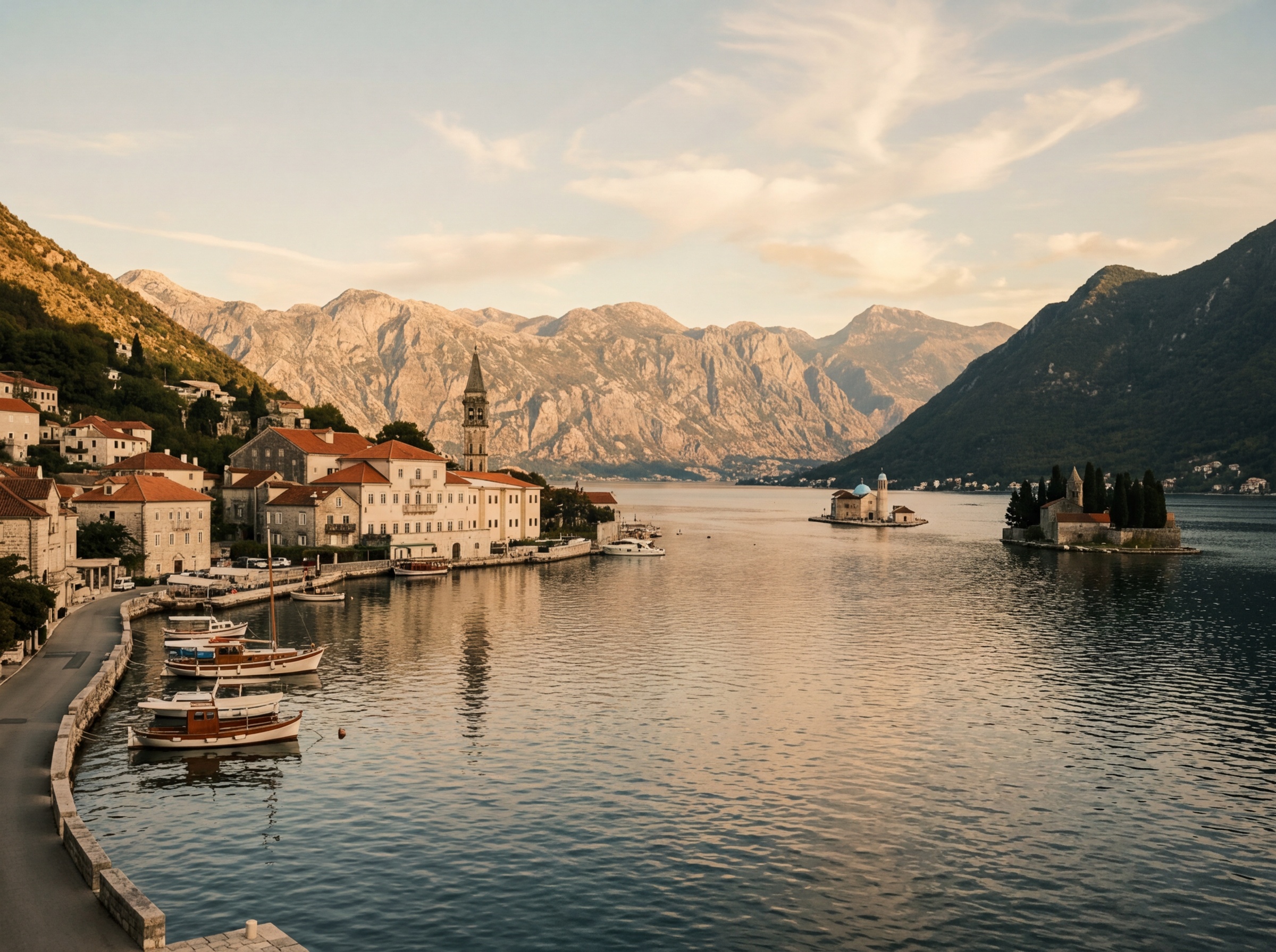
Perast: The One-Street Town
Perast is 12 km northwest of Kotor along the inner bay, and it is the most photographed spot on the entire loop. A single street of Baroque palaces lines the waterfront, with two tiny islands floating a few hundred meters offshore. The whole town takes 30 minutes to walk, and that is if you stop at every building.
The two islands:
- Our Lady of the Rocks (Gospa od Skrpjela): An artificial island built by locals who dropped stones into the bay for centuries. The church on top dates from 1630 and contains 68 paintings by Tripo Kokolja. Boat from Perast: EUR 5, 5 minutes each way.
- St. George (Sveti Djordje): A natural island with a Benedictine monastery. Off-limits to visitors, but photographs beautifully from Perast’s waterfront or from the boat to Our Lady of the Rocks.
Parking in Perast is extremely limited. There is a small lot at the north end of town (EUR 2/hour) and street spots along the approach road. In summer, parking is the main challenge. Arrive before 10 AM or after 4 PM.
Tip: The best photograph of Perast and both islands is from the road about 500 meters southeast of town, where a small pull-off gives you an elevated angle with the mountains behind. Morning light is best, but the afternoon glow on the stone facades is also excellent.
Herceg Novi: The Other End of the Bay
Continuing counterclockwise past the ferry landing at Kamenari, the road follows the outer bay toward Herceg Novi. This 25 km stretch is less dramatic than the inner bay but offers a different perspective — wider water, more open sky, and the bay’s entrance where it meets the Adriatic.
Herceg Novi sits at the bay’s mouth, guarding the entrance with several fortresses and a surprising amount of greenery — the town is full of mimosa trees, earning it the nickname “City of Flowers.” The Kanli Kula fortress above the Old Town (EUR 2 entry) has a summer stage for concerts and a panoramic view that takes in both the bay and the open sea.
The town is less tourist-polished than Kotor and more lived-in. The Topla district near the waterfront has good restaurants serving Montenegrin seafood — try the black risotto or the grilled squid. Lunch for two with wine runs EUR 25-35.
Parking in Herceg Novi is easier than Kotor. Street parking is available throughout the town (EUR 0.50-1/hour), and the lot near the Kanli Kula fortress has space even in summer.
The View from Above: Kotor Serpentines to Lovcen
If you have a car and a tolerance for switchbacks, the road from Kotor up to Lovcen National Park provides the definitive view of the Bay of Kotor — and arguably one of the best roadside panoramas in Europe.
The road begins at the back of Kotor and climbs 25 hairpin turns (they are numbered, helpfully) over 16 km to a viewpoint at about 900 meters elevation. Each switchback reveals more of the bay below, and by turn 15 you are looking down on cruise ships that look like toy boats.
Practical Details
| Detail | Info |
|---|---|
| Start point | Kotor, road to Cetinje/Lovcen |
| Distance to viewpoint | 16 km (25 switchbacks) |
| Drive time | 35-45 min (no rushing) |
| Road condition | Paved, narrow, no guardrails in places |
| Best time | Early morning or late afternoon for light |
| Suitable vehicles | Any car, but no wide SUVs if you are nervous |
Road character: The road is narrow — one and a half lanes wide in most sections. When two cars meet on a bend, one must yield. Tour buses also use this road, which creates moments of genuine suspense. There are no guardrails on many turns, and the drop-off is the kind that makes passengers close their eyes. Drive slowly, use your horn before blind corners, and pull over at the viewpoints to let faster traffic pass.
The reward at the top is extraordinary. At the main viewpoint (about 900 meters), the entire Bay of Kotor spreads below you — the inner bay, the outer bay, Perast’s islands, Kotor’s Old Town, and the mountains beyond. On a clear morning, you can see the Croatian coast.
Continuing to Cetinje or Lovcen
From the viewpoint, you can either turn around and descend back to Kotor (the road down is slightly less terrifying than the road up, since you can see what is coming) or continue to:
- Lovcen National Park: The mausoleum of Prince-Bishop Njegos sits at the summit (1,657 meters). It takes another 30 km of mountain road from the viewpoint to reach it. The mausoleum is dramatic — black granite inside a mountain peak — and the views from the top extend across Montenegro and into Albania. Entry EUR 5.
- Cetinje: Montenegro’s historic capital, 30 km inland. A quieter town with monasteries, museums, and a different atmosphere from the coast. The road from the serpentines to Cetinje is a proper mountain drive through empty landscapes.
Tip: Do not drive the Kotor serpentines at night. The road has no lighting, no guardrails, and the occasional wild turn that even GPS does not adequately warn you about. This is a daylight road.
Summer Traffic Realities
The Bay of Kotor road is beautiful in summer and congested in summer. These are not separate things — they happen simultaneously.
Cruise ship days: When multiple cruise ships dock in Kotor (which happens several times a week from May to October), the town fills with thousands of day-trippers and the road around the inner bay slows significantly. Tour buses heading to Perast and Herceg Novi compete for lane space with rental cars and local traffic.
The Croatian border: The Croatia-Montenegro crossing at Debeli Brijeg/Karasovici is the only road connection between the two countries on the coast. In July and August, waits of 1-2 hours are common. Cross before 8 AM or after 7 PM to avoid the worst queues.
Parking pressure: Every form of parking near Kotor and Perast is under extreme pressure from June through August. The Dobrota strategy (park 2 km away and walk) is not laziness — it is the rational response.
Off-season advantage: From October through April, the bay is quiet. The road is empty, parking is abundant, the ferry has no queue, and the views are identical. The weather is less predictable — winter rains are common — but the trade-off is obvious.
Combining the Bay of Kotor with Other Drives
The Bay of Kotor is a natural starting or ending point for several longer routes:
- From Croatia: The bay is 93 km south of Dubrovnik. The border crossing plus the bay loop makes a full day trip from Dubrovnik. See the Adriatic Coast route for the full itinerary.
- To the interior: From Kotor, the serpentine road leads to Cetinje and onward to Podgorica, connecting you to Durmitor National Park and the Tara Canyon.
- To Albania: From Herceg Novi, the coastal road continues south through Ulcinj to the Albanian border at Sukobin/Muriqan. The drive from the bay to Shkoder in Albania takes about 2.5 hours.
For more on driving in Montenegro, including speed limits and fuel costs, see our country hub. For the full pan-Balkan picture, our driving guide covers rules for all 9 countries.