Durmitor National Park by Car
There is a moment on the road to Durmitor when the Adriatic coast starts to feel like a different country. The palm trees and terracotta rooftops give way to dense pine forests, and the road narrows to a strip of asphalt carved into a mountainside with nothing between your tyres and a 300-meter drop except your own attention. You are in the Montenegrin highlands now, and the scale of everything — the canyon below, the peaks above, the silence when you step out of the car — makes the coast feel almost quaint.
Durmitor National Park sits in the northwest corner of Montenegro, centered around the small mountain town of Zabljak at 1,456 meters elevation. The park is home to the Tara Canyon (the deepest canyon in Europe and second in the world after the Grand Canyon), 18 glacial lakes, 48 peaks above 2,000 meters, and the kind of driving roads that remind you why you rented a car instead of taking a bus tour. We have driven to Durmitor from both the coast and from Podgorica, in summer and in the shoulder season, and each route offers a different version of Montenegro’s mountain personality.
Routes to Durmitor
Route 1: From the Coast via Podgorica (180 km, 3.5-4 hours)
This is the standard route and the one most road trippers use. From the Bay of Kotor or Budva, drive to Podgorica (about 90 minutes via the Sozina tunnel or the Cetinje road), then take the E65/M18 north through Moraca Canyon to Mojkovac and west to Zabljak.
Moraca Canyon is the highlight of this route. The road follows the Moraca River through a deep, narrow canyon with vertical limestone walls. The Moraca Monastery, a 13th-century Serbian Orthodox monastery built into the cliff face, makes a worthwhile 20-minute stop. The road is two lanes, well-maintained, and winding — not dangerous, but demanding enough that you should not try to rush it.
From Mojkovac, the road climbs westward into the Durmitor massif. The last 30 km to Zabljak are classic mountain driving: switchbacks, occasional livestock, and views that open up to alpine meadows and peaks as you gain elevation.
| Segment | Distance | Drive time | Road condition |
|---|---|---|---|
| Coast to Podgorica | 65-90 km | 1-1.5 hours | Good (tunnel or mountain road) |
| Podgorica to Mojkovac | 90 km | 1.5-2 hours | Good, canyon road |
| Mojkovac to Zabljak | 50 km | 1-1.5 hours | Moderate, mountain switchbacks |
| Total | ~180 km | 3.5-4 hours |
Route 2: Piva Canyon Alternative (from coast, ~200 km, 4-5 hours)
This route is longer and slower, but it is the more dramatic drive. From the coast, head to Niksic (Montenegro’s second city, about 2 hours from Budva) and then northwest through the Piva Canyon toward Scepan Polje on the Bosnian border. From there, the road follows the Tara River valley to Zabljak.
The Piva Canyon section is the star. The road tunnels through the mountainside, emerging periodically onto narrow ledges with views down into Piva Lake — a turquoise reservoir held back by one of the tallest arch dams in Europe (220 meters). The tunnels are unlit and the road is narrow. This is not a drive for nervous passengers or wide vehicles.
From the dam, the road continues through increasingly wild mountain scenery to the Tara River bridge (more on this below) and into Zabljak from the south.
We recommend this route for the return trip if you arrived via Podgorica. Doing the loop — up through Moraca Canyon, back through Piva Canyon — gives you two entirely different mountain experiences and avoids backtracking.
Route 3: From Serbia (Prijepolje, 100 km, 2 hours)
If you are coming from Serbia, the road from Prijepolje to Zabljak via Pljevlja crosses the border at Jabuka and runs through northern Montenegro’s timber country. The road is decent but empty. This route is practical rather than scenic.
Tip: Whichever route you choose, fill up your fuel tank before entering the mountains. The last reliable fuel station before Zabljak is in Mojkovac (from the east) or Niksic (from the south). Zabljak itself has a fuel station, but options are limited and prices are slightly higher.
The Tara Canyon Bridge
The Tara River Canyon Bridge (Durdevica Tara) is Montenegro’s most photographed piece of infrastructure, and for good reason. Built in 1940, it arcs 150 meters above the Tara River at the canyon’s deepest point. The five concrete arches span 365 meters across the gorge, and looking down from the bridge — or from the viewpoint 50 meters along the road — is a genuinely vertiginous experience.
The bridge is on the road between Zabljak and the Piva Canyon route, so you will cross it if you take Route 2 or the Durmitor Ring Road.
Stopping at the bridge:
Parking is available on both sides (free, informal lots). The eastern side has a small cafe with a terrace overlooking the canyon. The zip-line across the canyon (EUR 20, 350 meters long) launches from near the eastern end of the bridge — it runs May through October and takes about a minute to cross. The view from the zip-line is spectacular, though the experience is over before you fully process what is happening.
The best photograph of the bridge itself is from the eastern approach road, about 200 meters before the bridge, where you can see the full arc of the bridge with the canyon below.
Zabljak: The Mountain Base
Zabljak is the highest town in the Balkans at 1,456 meters, and it functions as the base for everything in Durmitor. It is small — a main street, a handful of hotels, some restaurants, a market, and an ATM that occasionally runs out of cash on summer weekends.
Accommodation
| Option | Price range | Notes |
|---|---|---|
| Hotels (Hotel Soa, Hotel Zabljak) | EUR 50-90 | Comfortable, central |
| Guesthouses/apartments | EUR 25-50 | Better value, many with mountain views |
| Mountain huts (in the park) | EUR 15-30 | Basic, for hikers |
| Camping | EUR 5-10 | At Mlinski Potok or informal sites |
Book ahead for July-August. Zabljak is small and accommodation fills up, particularly on weekends when Montenegrin and Serbian visitors head for the mountains.
Eating
Restaurant options are limited but solid. Montenegrin mountain food is heavy, meaty, and perfect after a day of driving or hiking. Order kacamak (a polenta-like dish with cheese and cream) or lamb cooked under the sac (a metal dome buried in coals). Lupo di Mare and Restoran Durmitor are both reliable. Expect EUR 10-15 per person for a full meal.
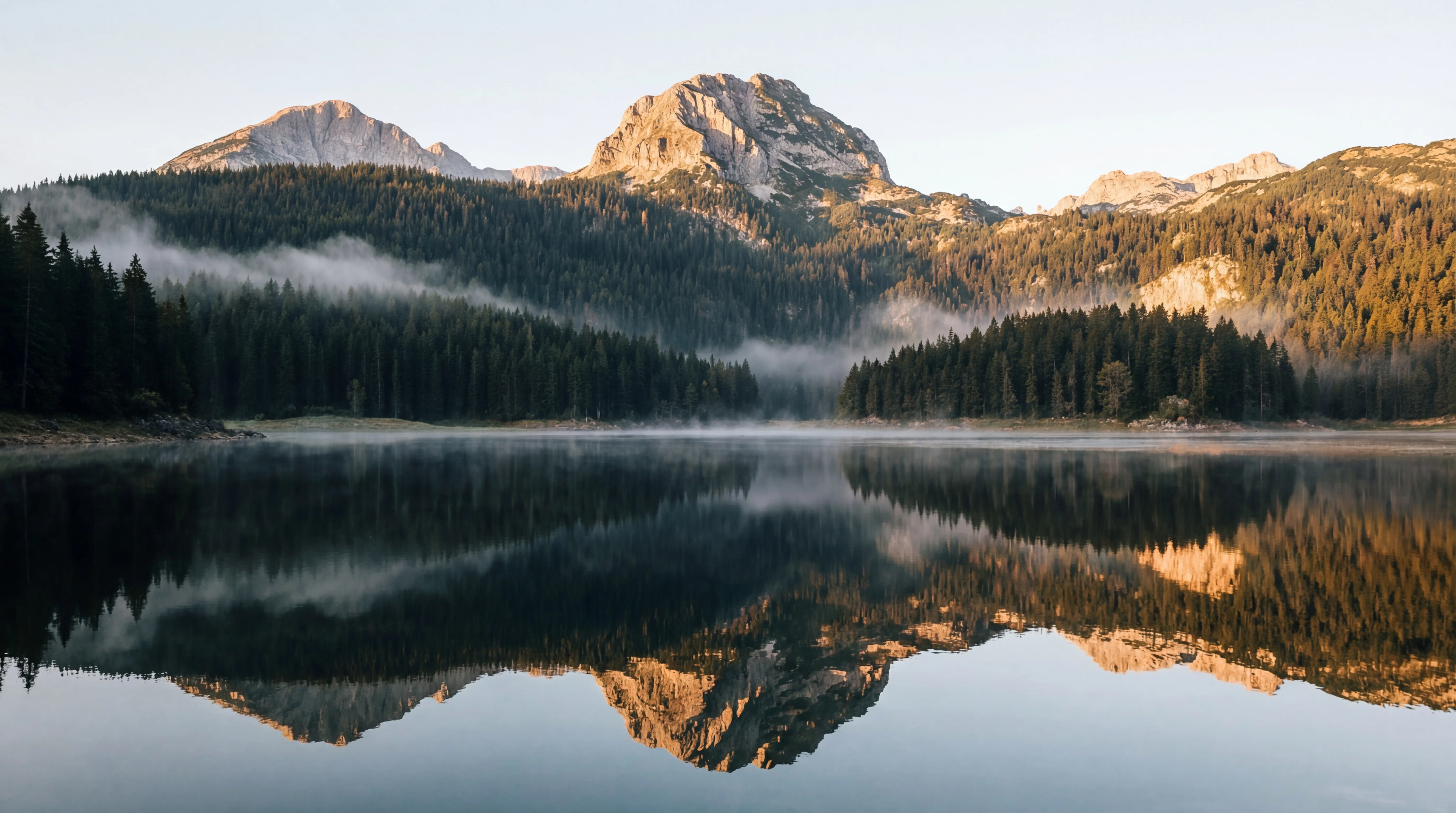
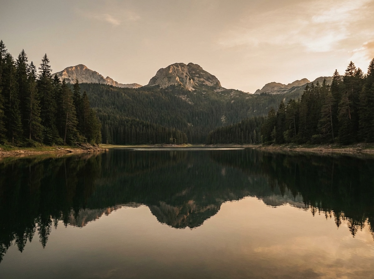
Black Lake (Crno Jezero)
Black Lake is Durmitor’s most accessible natural attraction and a legitimate reason to visit even if you do nothing else.
The lake is a 20-minute walk from Zabljak along a flat, paved path through a pine forest. The walk around the lake (3.5 km circumference) takes about an hour and is one of the most pleasant easy hikes in the Balkans. The lake sits at the foot of the Medjed peak (2,287 meters), and the reflection of the mountain in the still water on a calm morning is postcard material without the postcard.
Practical details:
| Detail | Info |
|---|---|
| Distance from Zabljak | 3 km (20 min walk or 5 min drive) |
| Parking | At the lake entrance, EUR 2 |
| Park entrance fee | EUR 3 per person |
| Walk around the lake | 3.5 km, 1 hour, flat |
| Swimming | Allowed but cold (rarely above 16 C in summer) |
| Best time | Early morning for reflections, calm water |
The lake is actually two lakes connected by a narrow channel that dries up in late summer, splitting it into Veliko (Big) and Malo (Small) Jezero. The full walk around both takes about 1.5 hours.
Tip: Early morning at Black Lake — before 8 AM — is when you get mirror-still water and the mountain reflection at its best. By mid-morning, the wind usually picks up and ripples the surface.
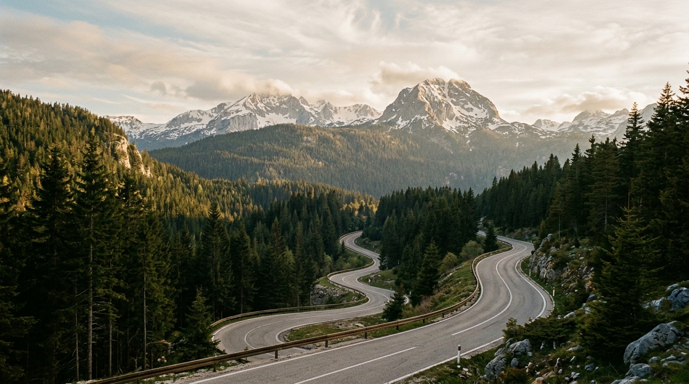
The Durmitor Ring Road (P14)
The P14 road makes a rough loop around the Durmitor massif, passing through some of Montenegro’s most remote and scenic mountain terrain. This is not a tourist loop road — it is a functional mountain road that happens to go through spectacular scenery.
Ring Road Overview
| Segment | Distance | Drive time | Surface | Notes |
|---|---|---|---|---|
| Zabljak to Tara Bridge | 25 km | 30 min | Paved | Good condition |
| Tara Bridge to Trsa | 15 km | 25 min | Paved | Some narrow sections |
| Trsa to Nedajno | 20 km | 45 min | Mixed paved/gravel | Rough in sections |
| Nedajno to Zabljak | 25 km | 40 min | Paved | Mountain pass |
| Full loop | ~85 km | 2.5-3 hours |
Road condition reality check: The P14 has sections of gravel and damaged asphalt, particularly between Trsa and Nedajno. After rain, the unpaved sections become muddy. A car with reasonable ground clearance handles it fine in dry conditions. In wet conditions or after heavy rain, an SUV is advisable. We did the full loop in a Renault Clio in September and made it, but the gravel sections required slow, careful driving.
The ring road passes through highland meadows (katuns), where seasonal shepherds bring their flocks in summer. You may encounter sheep, cattle, or horses on the road. This is not a metaphor — it is a regular Tuesday. Slow down, wait for them to move, and resist the urge to honk.
What You See
The ring road gives you alpine meadows, glacial valleys, pine forests, and distant views of the Tara and Piva canyons from above. The stretch between the Tara Bridge and Nedajno is the most dramatic, with the road traversing a high plateau surrounded by 2,000-meter peaks. In late June and early July, the meadows are carpeted with wildflowers.
Activities Beyond Driving
While this is a driving guide, Durmitor offers enough to justify parking the car for a day or two.
Rafting the Tara Canyon
The Tara River offers the most popular rafting experience in Montenegro. The standard full-day trip covers 18 km of the canyon, with Class III-IV rapids (depending on water level and season) and stops for swimming.
| Detail | Info |
|---|---|
| Duration | Full day (including transport from Zabljak) |
| Distance | 18 km river section |
| Difficulty | Class III-IV (moderate) |
| Price | EUR 50-70 per person |
| Season | May to October |
| Booking | Through Zabljak agencies or your hotel |
The rafting is genuinely good — not just “good for the Balkans” but good by any standard. The canyon walls rise up to 1,300 meters above the river, and the water is clear enough to see the bottom in the calmer sections. The rapids are fun without being dangerous for beginners. Multiple agencies in Zabljak run daily trips; book a day ahead in summer.
Hiking
Durmitor has over 100 km of marked trails, from easy lakeside walks to serious mountain routes. The top three accessible hikes:
| Hike | Difficulty | Time | What you see |
|---|---|---|---|
| Black Lake circuit | Easy | 1-1.5 hours | Glacial lake, mountain reflections |
| Jablan Lake | Easy-moderate | 2-3 hours | Second glacial lake, forest trails |
| Bobotov Kuk summit (2,523m) | Hard | 6-8 hours | Highest peak in Durmitor, panoramic views |
Bobotov Kuk is a serious mountain hike and requires proper equipment, early departure, and good weather. The trail is well-marked but exposed above the tree line. Check weather conditions in Zabljak before attempting it.
Snow Season and Road Closures
Durmitor is also a ski resort (small, old-fashioned, cheap by European standards), which tells you something about winter conditions. Snow typically covers the area from November through April, and sometimes into May at higher elevations.
Road closures:
- The Piva Canyon route (Route 2) can close during heavy snowfall, typically December through March.
- The Durmitor Ring Road (P14) is impassable in winter due to snow and is usually closed from November through May.
- The main road to Zabljak from Mojkovac (Route 1) is maintained in winter but requires winter tyres and sometimes chains. Snow plows operate, but not instantly.
If you visit in winter: The main road from Podgorica via Moraca Canyon to Zabljak is your only reliable option. Winter tyres are mandatory in practice (and in Montenegrin law from November through March). Carry chains as backup. The drive takes longer in winter conditions — add an hour to the summer driving times.
Tip: May and early June are the sweet spot: the Piva Canyon route and ring road are open, the snow has melted from the hiking trails (mostly), and the summer crowds have not yet arrived. Black Lake in June, ringed by blooming meadows with snow still on the peaks, is Durmitor at its finest.
Practical Details
Fuel
Fill up before coming. The last fuel stations before Zabljak are:
- From the east: Mojkovac (50 km from Zabljak)
- From the south: Niksic (80 km via Piva Canyon route)
- Zabljak has one fuel station, but lines can form on summer weekends
Road Conditions Summary
| Road | Surface | Guardrails | Width | Suitable for |
|---|---|---|---|---|
| Podgorica-Mojkovac (E65) | Good asphalt | Yes | 2 lanes | Any car |
| Mojkovac-Zabljak | Fair asphalt | Partial | Narrow 2 lanes | Any car, carefully |
| Piva Canyon road | Fair asphalt | Partial | Narrow, tunnels | Any car, carefully. Tunnels unlit. |
| Durmitor Ring Road (P14) | Mixed | Minimal | 1-1.5 lanes | Higher clearance recommended |
| Zabljak-Black Lake | Good asphalt | Yes | 2 lanes | Any car |
Driving Tips for the Mountains
- Use your horn on blind corners. Montenegro’s mountain roads have blind bends where oncoming traffic is invisible until the last moment. A short honk before each turn is standard practice.
- Pull over for faster traffic. If someone behind you clearly knows the road better, find a spot and let them pass. Mountain etiquette.
- Watch for livestock. Cows, sheep, and horses use the road. They have the right of way in the sense that they will not move, and they are larger than your car.
- No night driving. Mountain roads in Montenegro are unlit. The combination of narrow roads, sharp drops, no guardrails, and potential animals makes night driving genuinely dangerous. Plan to arrive in Zabljak before dark.
Combining Durmitor with Other Destinations
Durmitor connects logically to several routes:
- Bay of Kotor: Drive the coast in the morning, arrive in Durmitor by late afternoon via Podgorica. See our Bay of Kotor driving guide.
- Bosnia: From the Tara Canyon bridge, the road continues west to Scepan Polje at the Bosnian border. From there, Foca (45 km) and Sarajevo (180 km) are reachable. The Bosnia crossing at Scepan Polje is quiet and fast.
- Serbia: From Mojkovac, the road continues north to the Serbian border at Dobrakovo. Prijepolje and Zlatibor are 2-3 hours away.
- Albania: From Zabljak, drive to Podgorica (2.5 hours) and then south to the Albanian border at Bozaj/Hani i Hotit. Total about 4 hours to Shkoder.
For more on driving in Montenegro, see our country hub. For the full Balkan road trip picture, the driving guide covers rules and conditions in all 9 countries.